Dzibikak geodata
Dzibikak (Yucatán) is a populated place; located in Mexico in America/Merida (GMT-6) time zone. With population of 1,388 people, there are 6234 cities with bigger population in this country. Compared to other cities in Mexico, 74.8% of cities are located further ↓South; 97.7% of cities are located further ←West and 97% of cities have higher elevation than Dzibikak. Note1


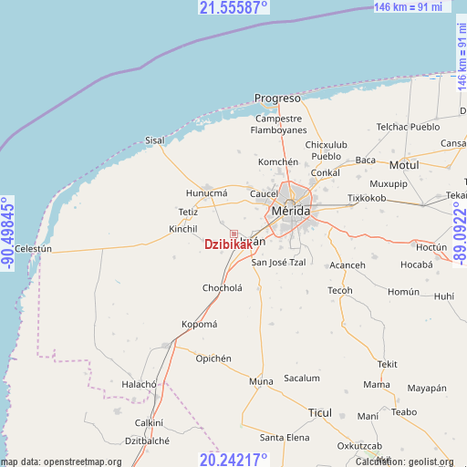
Dzibikak GPS coordinates[2]
20° 54' 1.656" North, 89° 47' 43.152" West
| Map corner | latitude | longitude |
|---|---|---|
| Upper-left | 21.55587°, | -90.49845° |
| Center: | 20.90046°, | -89.79532° |
| Lower-right: | 20.24217°, | -89.0922° |
| Map W x H: | 146.1×146.1 km | = 90.8×90.8mi |
| max Lat: | 32.7° ⇑25.2% North |
| Dzibikak: | 20.90046° |
| min Lat: | ⇓74.8% South 14.53588° |
| min Long | Dzibikak | max Long |
| -117.105° | -89.79532° | -86.73105° |
| W 97.7%⇐ | ⇒2.3% E |
Elevation
Elevation of Dzibikak is 10 m = 33 ft, and this is 1243.7 m = 4080 ft below average elevation for this country.
| Max E: |
3497 m = 11473 ft | 97% |
| Avg. | 1253.7 m = 4113 ft | |
| Dzibikak | 10 m = 33 ft | |
Min E: |
-1 m = -3 ft | 3% |
See also: Mexico elevation on elevation.city.
Geographical zone
Dzibikak is located in North Torrid zone (between Equator and Tropic of Cancer). Distance of this Northern Tropic circle is 282 km =175.2 mi to North.| Distance of | km | miles | from Dzibikak |
|---|---|---|---|
| North Pole | 7683.1 | 4774.1 | to North |
| Arctic Circle | 5077.3 | 3154.9 | to North |
| Tropic Cancer | 282 | 175.2 | to North |
| Equator | 2323.9 | 1444 | to South |


Nearby cities:
15 places around Dzibikak: (largest is in red/bold)
• Bolón
6.8 km =4.2 mi,  214°
214°
• Dzununcan
15.2 km =9.4 mi,  105°
105°
• Itzincab Palomeque
10.2 km =6.3 mi,  80°
80°
• Kuchel
12 km =7.5 mi,  242°
242°
• Opichen
13.2 km =8.2 mi,  65°
65°
• Oxcum
6.1 km =3.8 mi,  34°
34°
• Poxila
9.2 km =5.7 mi,  185°
185°
• Samahil
9.8 km =6.1 mi,  258°
258°
• San Antonio Chum
7.2 km =4.5 mi,  249°
249°
• Santa Cruz Palomeque
14.9 km =9.3 mi,  98°
98°
• Texan de Palomeque
5.7 km =3.5 mi,  316°
316°
• Ticimul
11.8 km =7.3 mi, 100°
• Tizcacal Opichen
9.7 km =6 mi,  59°
59°
• Uman
5.5 km =3.4 mi, 111°
• Xtepen
10.2 km =6.3 mi,  148°
148°
Sources, notices
• [Note1] Compared only with cities in Mexico existing in our database
• [Src1] Map data: © OpenStreetMap contributors (CC-BY-SA)
• [Src2] Other city data from geonames.org with taken over terms of usage.
• [Src3] Geographical zone / Annual Mean Temperature by Robert A. Rohde @ Wikipedia
