Sabanilla geodata
Sabanilla (Chiapas) is a seat of a second-order administrative division; located in Mexico in America/Mexico_City (GMT-6) time zone. With population of 3,052 people, there are 2951 cities with bigger population in this country. Compared to other cities in Mexico, 85.5% of cities are located further ↑North; 91.4% of cities are located further ←West and 73.7% of cities have higher elevation than Sabanilla. Note1


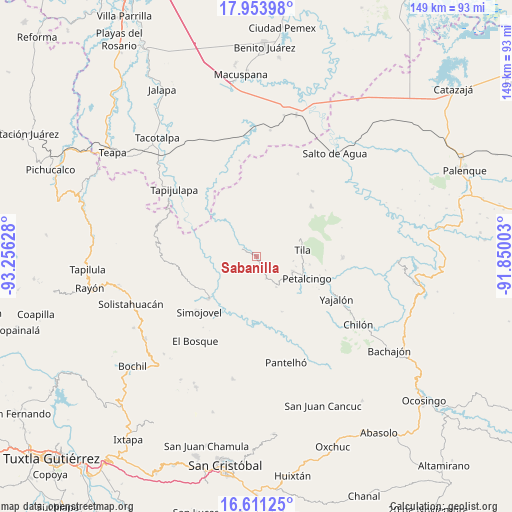
Sabanilla GPS coordinates[2]
17° 17' 1.824" North, 92° 33' 11.34" West
| Map corner | latitude | longitude |
|---|---|---|
| Upper-left | 17.95398°, | -93.25628° |
| Center: | 17.28384°, | -92.55315° |
| Lower-right: | 16.61125°, | -91.85003° |
| Map W x H: | 149.3×149.3 km | = 92.8×92.8mi |
| max Lat: | 32.7° ⇑85.5% North |
| Sabanilla: | 17.28384° |
| min Lat: | ⇓14.5% South 14.53588° |
| min Long | Sabanilla | max Long |
| -117.105° | -92.55315° | -86.73105° |
| W 91.4%⇐ | ⇒8.6% E |
Elevation
Elevation of Sabanilla is 266 m = 873 ft, and this is 987.7 m = 3240 ft below average elevation for this country.
| Max E: |
3497 m = 11473 ft | 73.7% |
| Avg. | 1253.7 m = 4113 ft | |
| Sabanilla | 266 m = 873 ft | |
Min E: |
-1 m = -3 ft | 26.3% |
See also: Mexico elevation on elevation.city.
Geographical zone
Sabanilla is located in North Torrid zone (between Equator and Tropic of Cancer). Distance of this Northern Tropic circle is 684.1 km =425.1 mi to North.| Distance of | km | miles | from Sabanilla |
|---|---|---|---|
| North Pole | 8085.3 | 5024 | to North |
| Arctic Circle | 5479.4 | 3404.7 | to North |
| Tropic Cancer | 684.1 | 425.1 | to North |
| Equator | 1921.8 | 1194.2 | to South |


Nearby cities:
15 places around Sabanilla: (largest is in red/bold)
• Asunción Huitiupan
6.6 km =4.1 mi,  198°
198°
• Buenavista
7.1 km =4.4 mi,  156°
156°
• Chinintié
7.4 km =4.6 mi,  123°
123°
• Chulum Juárez
5.7 km =3.5 mi,  20°
20°
• Coquija
7.2 km =4.5 mi,  92°
92°
• El Calvario
7.4 km =4.6 mi,  183°
183°
• El Ocotal
5.2 km =3.2 mi, 92°
• El Paraíso
4.2 km =2.6 mi,  185°
185°
• Jolsibaquil
8 km =5 mi,  109°
109°
• La Revolución
3.5 km =2.2 mi,  69°
69°
• Los Naranjos
7.4 km =4.6 mi,  253°
253°
• Lázaro Cárdenas
8.1 km =5 mi,  212°
212°
• Majastic
8 km =5 mi,  274°
274°
• Ostelucum
9.2 km =5.7 mi,  328°
328°
• Tiontiepa Benito Juárez
8.2 km =5.1 mi,  78°
78°
Sources, notices
• [Note1] Compared only with cities in Mexico existing in our database
• [Src1] Map data: © OpenStreetMap contributors (CC-BY-SA)
• [Src2] Other city data from geonames.org with taken over terms of usage.
• [Src3] Geographical zone / Annual Mean Temperature by Robert A. Rohde @ Wikipedia
