Ostelucum geodata
Ostelucum (Chiapas) is a populated place; located in Mexico in America/Mexico_City (GMT-6) time zone. With population of 503 people, there are 16722 cities with bigger population in this country. Compared to other cities in Mexico, 84.7% of cities are located further ↑North; 91.2% of cities are located further ←West and 65.3% of cities have higher elevation than Ostelucum. Note1


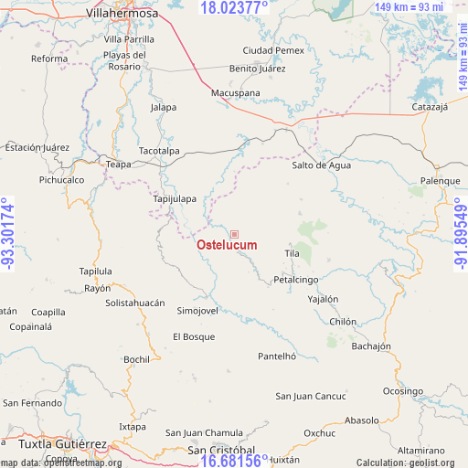
Ostelucum GPS coordinates[2]
17° 21' 14.004" North, 92° 35' 54.996" West
| Map corner | latitude | longitude |
|---|---|---|
| Upper-left | 18.02377°, | -93.30174° |
| Center: | 17.35389°, | -92.59861° |
| Lower-right: | 16.68156°, | -91.89549° |
| Map W x H: | 149.2×149.2 km | = 92.7×92.7mi |
| max Lat: | 32.7° ⇑84.7% North |
| Ostelucum: | 17.35389° |
| min Lat: | ⇓15.3% South 14.53588° |
| min Long | Ostelucum | max Long |
| -117.105° | -92.59861° | -86.73105° |
| W 91.2%⇐ | ⇒8.8% E |
Elevation
Elevation of Ostelucum is 673 m = 2208 ft, and this is 580.7 m = 1905 ft below average elevation for this country.
| Max E: |
3497 m = 11473 ft | 65.3% |
| Avg. | 1253.7 m = 4113 ft | |
| Ostelucum | 673 m = 2208 ft | |
Min E: |
-1 m = -3 ft | 34.7% |
See also: Mexico elevation on elevation.city.
Geographical zone
Ostelucum is located in North Torrid zone (between Equator and Tropic of Cancer). Distance of this Northern Tropic circle is 676.3 km =420.2 mi to North.| Distance of | km | miles | from Ostelucum |
|---|---|---|---|
| North Pole | 8077.5 | 5019.1 | to North |
| Arctic Circle | 5471.6 | 3399.9 | to North |
| Tropic Cancer | 676.3 | 420.2 | to North |
| Equator | 1929.6 | 1199 | to South |


Nearby cities:
15 places around Ostelucum: (largest is in red/bold)
• Campamento el Mirador
8.5 km =5.3 mi,  267°
267°
• Chulum Cárdenas
4.3 km =2.7 mi,  37°
37°
• Chulum Juárez
7.3 km =4.5 mi,  109°
109°
• Cristóbal Colón
6.1 km =3.8 mi, 270°
• El Bebedero
7.1 km =4.4 mi,  312°
312°
• Jesús Carranza
8.8 km =5.5 mi,  317°
317°
• La Revolución
10.4 km =6.5 mi,  129°
129°
• Los Naranjos
10.2 km =6.3 mi,  192°
192°
• Majastic
7.8 km =4.8 mi,  203°
203°
• Moyos
4.6 km =2.9 mi,  276°
276°
• Raya Zaragoza
10.9 km =6.8 mi,  302°
302°
• Sabanilla
9.2 km =5.7 mi,  148°
148°
• Unión Hidalgo (El Chorro)
0.9 km =0.6 mi,  338°
338°
• Unión Juárez
4.9 km =3 mi, 318°
• Álvaro Obregón
11.6 km =7.2 mi,  28°
28°
Sources, notices
• [Note1] Compared only with cities in Mexico existing in our database
• [Src1] Map data: © OpenStreetMap contributors (CC-BY-SA)
• [Src2] Other city data from geonames.org with taken over terms of usage.
• [Src3] Geographical zone / Annual Mean Temperature by Robert A. Rohde @ Wikipedia
