Los Naranjos geodata
Los Naranjos (Chiapas) is a populated place; located in Mexico in America/Mexico_City (GMT-6) time zone. With population of 2,348 people, there are 3760 cities with bigger population in this country. Compared to other cities in Mexico, 85.7% of cities are located further ↑North; 91% of cities are located further ←West and 58.6% of cities have higher elevation than Los Naranjos. Note1


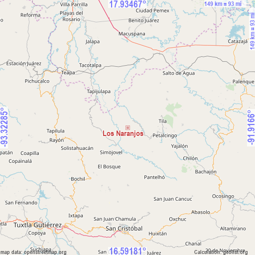
Los Naranjos GPS coordinates[2]
17° 15' 52.056" North, 92° 37' 10.992" West
| Map corner | latitude | longitude |
|---|---|---|
| Upper-left | 17.93467°, | -93.32285° |
| Center: | 17.26446°, | -92.61972° |
| Lower-right: | 16.59181°, | -91.9166° |
| Map W x H: | 149.3×149.3 km | = 92.8×92.8mi |
| max Lat: | 32.7° ⇑85.7% North |
| Los Naranjos: | 17.26446° |
| min Lat: | ⇓14.3% South 14.53588° |
| min Long | Los Naranjos | max Long |
| -117.105° | -92.61972° | -86.73105° |
| W 91%⇐ | ⇒9% E |
Elevation
Elevation of Los Naranjos is 1077 m = 3533 ft, and this is 176.7 m = 580 ft below average elevation for this country.
| Max E: |
3497 m = 11473 ft | 58.6% |
| Avg. | 1253.7 m = 4113 ft | |
| Los Naranjos | 1077 m = 3533 ft | |
Min E: |
-1 m = -3 ft | 41.4% |
See also: Mexico elevation on elevation.city.
Geographical zone
Los Naranjos is located in North Torrid zone (between Equator and Tropic of Cancer). Distance of this Northern Tropic circle is 686.3 km =426.4 mi to North.| Distance of | km | miles | from Los Naranjos |
|---|---|---|---|
| North Pole | 8087.4 | 5025.3 | to North |
| Arctic Circle | 5481.5 | 3406 | to North |
| Tropic Cancer | 686.3 | 426.4 | to North |
| Equator | 1919.6 | 1192.8 | to South |


Nearby cities:
15 places around Los Naranjos: (largest is in red/bold)
• Asunción Huitiupan
6.4 km =4 mi,  129°
129°
• Buenavista
10.8 km =6.7 mi,  113°
113°
• Cristóbal Colón
10.7 km =6.6 mi,  338°
338°
• El Azufre
7.2 km =4.5 mi,  202°
202°
• El Calvario
8.5 km =5.3 mi, 128°
• El Paraíso
7 km =4.3 mi, 106°
• Emiliano Zapata
2.4 km =1.5 mi,  239°
239°
• José María Morelos y Pavón
9.1 km =5.7 mi,  253°
253°
• Lázaro Cárdenas
5.4 km =3.4 mi,  150°
150°
• Majastic
2.9 km =1.8 mi, 341°
• Moyos
10.7 km =6.6 mi,  347°
347°
• Ostelucum
10.2 km =6.3 mi,  12°
12°
• Ramos Cubilete
6.6 km =4.1 mi,  264°
264°
• Sabanilla
7.4 km =4.6 mi,  73°
73°
• Villa Luz
10.6 km =6.6 mi,  279°
279°
Sources, notices
• [Note1] Compared only with cities in Mexico existing in our database
• [Src1] Map data: © OpenStreetMap contributors (CC-BY-SA)
• [Src2] Other city data from geonames.org with taken over terms of usage.
• [Src3] Geographical zone / Annual Mean Temperature by Robert A. Rohde @ Wikipedia
