Quetzalapa geodata
Quetzalapa (Guerrero) is a populated place; located in Mexico in America/Mexico_City (GMT-6) time zone. With population of 1,640 people, there are 5286 cities with bigger population in this country. Compared to other cities in Mexico, 91.9% of cities are located further ↑North; 57.2% of cities are located further ←West and 69.7% of cities have higher elevation than Quetzalapa. Note1


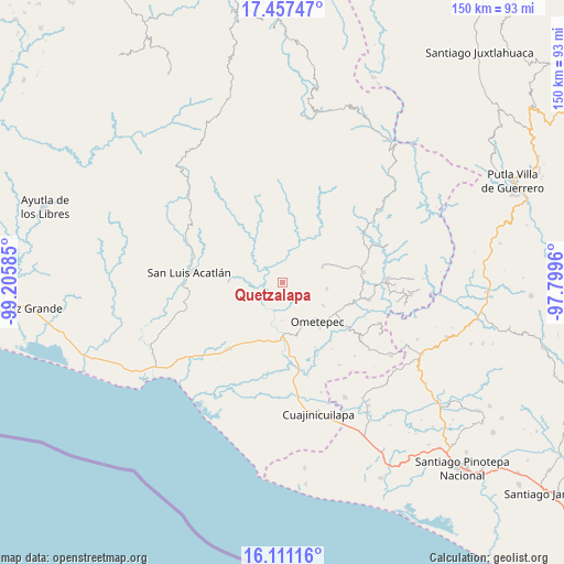
Quetzalapa GPS coordinates[2]
16° 47' 7.836" North, 98° 30' 9.792" West
| Map corner | latitude | longitude |
|---|---|---|
| Upper-left | 17.45747°, | -99.20585° |
| Center: | 16.78551°, | -98.50272° |
| Lower-right: | 16.11116°, | -97.7996° |
| Map W x H: | 149.7×149.7 km | = 93×93mi |
| max Lat: | 32.7° ⇑91.9% North |
| Quetzalapa: | 16.78551° |
| min Lat: | ⇓8.1% South 14.53588° |
| min Long | Quetzalapa | max Long |
| -117.105° | -98.50272° | -86.73105° |
| W 57.2%⇐ | ⇒42.8% E |
Elevation
Elevation of Quetzalapa is 430 m = 1411 ft, and this is 823.7 m = 2702 ft below average elevation for this country.
| Max E: |
3497 m = 11473 ft | 69.7% |
| Avg. | 1253.7 m = 4113 ft | |
| Quetzalapa | 430 m = 1411 ft | |
Min E: |
-1 m = -3 ft | 30.3% |
See also: Mexico elevation on elevation.city.
Geographical zone
Quetzalapa is located in North Torrid zone (between Equator and Tropic of Cancer). Distance of this Northern Tropic circle is 739.5 km =459.5 mi to North.| Distance of | km | miles | from Quetzalapa |
|---|---|---|---|
| North Pole | 8140.7 | 5058.4 | to North |
| Arctic Circle | 5534.8 | 3439.2 | to North |
| Tropic Cancer | 739.5 | 459.5 | to North |
| Equator | 1866.4 | 1159.7 | to South |


Nearby cities:
15 places around Quetzalapa: (largest is in red/bold)
• Acalmani
3.4 km =2.1 mi,  353°
353°
• Acatepec
9.6 km =6 mi,  123°
123°
• Azoyú
12 km =7.5 mi,  241°
241°
• Chacalapa
5.3 km =3.3 mi,  63°
63°
• Cruz de Corazón
12.1 km =7.5 mi,  147°
147°
• Igualapa
5.2 km =3.2 mi, 147°
• La Soledad
12.2 km =7.6 mi, 119°
• Las Vigas
13.1 km =8.1 mi,  157°
157°
• Llano Grande de Juárez
12.8 km =8 mi,  12°
12°
• Llano Grande de los Hilarios
7.3 km =4.5 mi,  112°
112°
• Maxmadi
9.3 km =5.8 mi,  258°
258°
• San Cristóbal
11.4 km =7.1 mi,  69°
69°
• San José Buenavista
7.4 km =4.6 mi, 5°
• Santa María
12 km =7.5 mi,  98°
98°
• Villa Hidalgo
13 km =8.1 mi, 120°
Sources, notices
• [Note1] Compared only with cities in Mexico existing in our database
• [Src1] Map data: © OpenStreetMap contributors (CC-BY-SA)
• [Src2] Other city data from geonames.org with taken over terms of usage.
• [Src3] Geographical zone / Annual Mean Temperature by Robert A. Rohde @ Wikipedia
