Santa María geodata
Santa María (Guerrero) is a populated place; located in Mexico in America/Mexico_City (GMT-6) time zone. With population of 2,230 people, there are 3939 cities with bigger population in this country. Compared to other cities in Mexico, 92.1% of cities are located further ↑North; 58.7% of cities are located further ←West and 67.2% of cities have higher elevation than Santa María. Note1


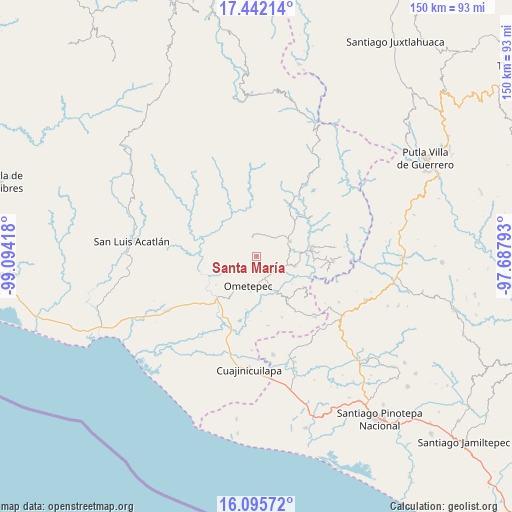
Santa María GPS coordinates[2]
16° 46' 12.432" North, 98° 23' 27.78" West
| Map corner | latitude | longitude |
|---|---|---|
| Upper-left | 17.44214°, | -99.09418° |
| Center: | 16.77012°, | -98.39105° |
| Lower-right: | 16.09572°, | -97.68793° |
| Map W x H: | 149.7×149.7 km | = 93×93mi |
| max Lat: | 32.7° ⇑92.1% North |
| Santa María: | 16.77012° |
| min Lat: | ⇓7.9% South 14.53588° |
| min Long | Santa María | max Long |
| -117.105° | -98.39105° | -86.73105° |
| W 58.7%⇐ | ⇒41.3% E |
Elevation
Elevation of Santa María is 575 m = 1886 ft, and this is 678.7 m = 2227 ft below average elevation for this country.
| Max E: |
3497 m = 11473 ft | 67.2% |
| Avg. | 1253.7 m = 4113 ft | |
| Santa María | 575 m = 1886 ft | |
Min E: |
-1 m = -3 ft | 32.8% |
See also: Mexico elevation on elevation.city.
Geographical zone
Santa María is located in North Torrid zone (between Equator and Tropic of Cancer). Distance of this Northern Tropic circle is 741.3 km =460.6 mi to North.| Distance of | km | miles | from Santa María |
|---|---|---|---|
| North Pole | 8142.4 | 5059.5 | to North |
| Arctic Circle | 5536.5 | 3440.2 | to North |
| Tropic Cancer | 741.3 | 460.6 | to North |
| Equator | 1864.7 | 1158.7 | to South |


Nearby cities:
15 places around Santa María: (largest is in red/bold)
• Acatepec
5.3 km =3.3 mi,  226°
226°
• Chacalapa
8.2 km =5.1 mi,  299°
299°
• Cochoapa
5.7 km =3.5 mi,  159°
159°
• Cruz de Corazón
10.1 km =6.3 mi,  212°
212°
• Cumbre de Barranca Honda
7.2 km =4.5 mi,  126°
126°
• Igualapa
9.5 km =5.9 mi,  253°
253°
• La Soledad
4.4 km =2.7 mi,  196°
196°
• Llano Grande de los Hilarios
5.3 km =3.3 mi,  258°
258°
• Ometepec
9.1 km =5.7 mi,  191°
191°
• Quetzalapa
12 km =7.5 mi,  278°
278°
• San Cristóbal
5.9 km =3.7 mi,  347°
347°
• San Jerónimo
12.4 km =7.7 mi,  14°
14°
• Tlacoachistlahuaca
10.6 km =6.6 mi,  64°
64°
• Villa Hidalgo
4.9 km =3 mi, 187°
• Zacoalpan
11.4 km =7.1 mi,  104°
104°
Sources, notices
• [Note1] Compared only with cities in Mexico existing in our database
• [Src1] Map data: © OpenStreetMap contributors (CC-BY-SA)
• [Src2] Other city data from geonames.org with taken over terms of usage.
• [Src3] Geographical zone / Annual Mean Temperature by Robert A. Rohde @ Wikipedia
