Azoyú geodata
Azoyú (Guerrero) is a seat of a second-order administrative division; located in Mexico in America/Mexico_City (GMT-6) time zone. With population of 4,211 people, there are 2180 cities with bigger population in this country. Compared to other cities in Mexico, 92.5% of cities are located further ↑North; 56.1% of cities are located further ←West and 71% of cities have higher elevation than Azoyú. Note1


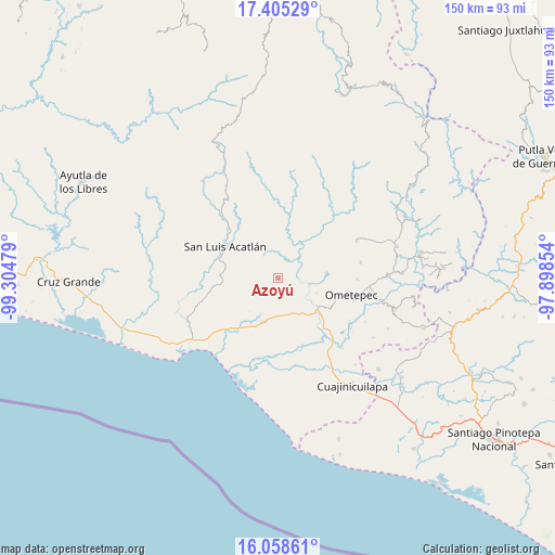
Azoyú GPS coordinates[2]
16° 43' 59.304" North, 98° 36' 5.976" West
| Map corner | latitude | longitude |
|---|---|---|
| Upper-left | 17.40529°, | -99.30479° |
| Center: | 16.73314°, | -98.60166° |
| Lower-right: | 16.05861°, | -97.89854° |
| Map W x H: | 149.7×149.7 km | = 93×93mi |
| max Lat: | 32.7° ⇑92.5% North |
| Azoyú: | 16.73314° |
| min Lat: | ⇓7.5% South 14.53588° |
| min Long | Azoyú | max Long |
| -117.105° | -98.60166° | -86.73105° |
| W 56.1%⇐ | ⇒43.9% E |
Elevation
Elevation of Azoyú is 369 m = 1211 ft, and this is 884.7 m = 2903 ft below average elevation for this country.
| Max E: |
3497 m = 11473 ft | 71% |
| Avg. | 1253.7 m = 4113 ft | |
| Azoyú | 369 m = 1211 ft | |
Min E: |
-1 m = -3 ft | 29% |
See also: Mexico elevation on elevation.city.
Geographical zone
Azoyú is located in North Torrid zone (between Equator and Tropic of Cancer). Distance of this Northern Tropic circle is 745.4 km =463.2 mi to North.| Distance of | km | miles | from Azoyú |
|---|---|---|---|
| North Pole | 8146.5 | 5062 | to North |
| Arctic Circle | 5540.6 | 3442.8 | to North |
| Tropic Cancer | 745.4 | 463.2 | to North |
| Equator | 1860.6 | 1156.1 | to South |


Nearby cities:
15 places around Azoyú: (largest is in red/bold)
• Acalmani
13.7 km =8.5 mi,  47°
47°
• Arcelia de Rodríguez
4.6 km =2.9 mi,  274°
274°
• Cuanacaxtitlán
8.4 km =5.2 mi,  331°
331°
• Huehuetán
11.7 km =7.3 mi,  157°
157°
• Igualapa
13.4 km =8.3 mi,  84°
84°
• Jolotichán
13.9 km =8.6 mi,  278°
278°
• Juchitán
12.8 km =8 mi,  198°
198°
• Maxmadi
4.2 km =2.6 mi,  19°
19°
• Quetzalapa
12 km =7.5 mi,  61°
61°
• San Isidro el Puente (El Puente)
9.1 km =5.7 mi, 197°
• San Juan de los Llanos
13.8 km =8.6 mi,  128°
128°
• Tenango
10.4 km =6.5 mi,  135°
135°
• Yoloxóchitl
12.9 km =8 mi,  315°
315°
• Zapotitlán de la Fuente (El Zapote)
2.3 km =1.4 mi,  256°
256°
• Zoyatlán
14.3 km =8.9 mi, 259°
Sources, notices
• [Note1] Compared only with cities in Mexico existing in our database
• [Src1] Map data: © OpenStreetMap contributors (CC-BY-SA)
• [Src2] Other city data from geonames.org with taken over terms of usage.
• [Src3] Geographical zone / Annual Mean Temperature by Robert A. Rohde @ Wikipedia
