Pozuelo geodata
Pozuelo (Veracruz) is a populated place; located in Mexico in America/Mexico_City (GMT-6) time zone. With population of 575 people, there are 14908 cities with bigger population in this country. Compared to other cities in Mexico, 68.3% of cities are located further ↑North; 81.9% of cities are located further ←West and 94% of cities have higher elevation than Pozuelo. Note1


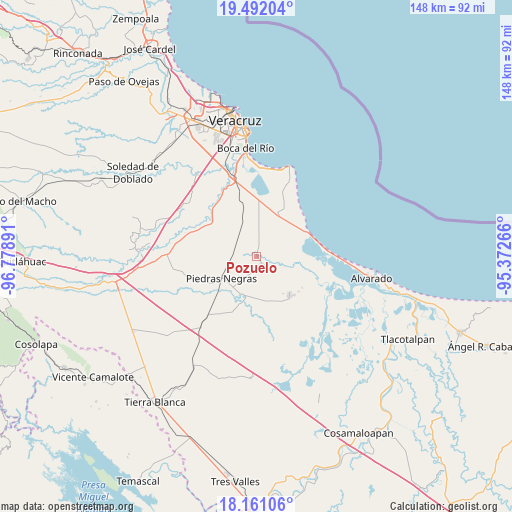
Pozuelo GPS coordinates[2]
18° 49' 40.332" North, 96° 4' 32.808" West
| Map corner | latitude | longitude |
|---|---|---|
| Upper-left | 19.49204°, | -96.77891° |
| Center: | 18.82787°, | -96.07578° |
| Lower-right: | 18.16106°, | -95.37266° |
| Map W x H: | 148×148 km | = 92×92mi |
| max Lat: | 32.7° ⇑68.3% North |
| Pozuelo: | 18.82787° |
| min Lat: | ⇓31.7% South 14.53588° |
| min Long | Pozuelo | max Long |
| -117.105° | -96.07578° | -86.73105° |
| W 81.9%⇐ | ⇒18.1% E |
Elevation
Elevation of Pozuelo is 15 m = 49 ft, and this is 1238.7 m = 4064 ft below average elevation for this country.
| Max E: |
3497 m = 11473 ft | 94% |
| Avg. | 1253.7 m = 4113 ft | |
| Pozuelo | 15 m = 49 ft | |
Min E: |
-1 m = -3 ft | 6% |
See also: Mexico elevation on elevation.city.
Geographical zone
Pozuelo is located in North Torrid zone (between Equator and Tropic of Cancer). Distance of this Northern Tropic circle is 512.5 km =318.5 mi to North.| Distance of | km | miles | from Pozuelo |
|---|---|---|---|
| North Pole | 7913.6 | 4917.3 | to North |
| Arctic Circle | 5307.7 | 3298.1 | to North |
| Tropic Cancer | 512.5 | 318.5 | to North |
| Equator | 2093.5 | 1300.8 | to South |


Nearby cities:
15 places around Pozuelo: (largest is in red/bold)
• El Cocuite
12.3 km =7.6 mi,  184°
184°
• El Ojochal
13.4 km =8.3 mi,  165°
165°
• El Sauce (Cerro Grande)
12.9 km =8 mi, 176°
• El Zapote
8.3 km =5.2 mi,  217°
217°
• El Zapote
15.8 km =9.8 mi,  130°
130°
• Ignacio de la Llave
14.7 km =9.1 mi,  140°
140°
• La Piedra
13.6 km =8.5 mi,  28°
28°
• Mata Cabestro (La Víbora)
9.6 km =6 mi,  4°
4°
• Moyotla
13.4 km =8.3 mi,  151°
151°
• Palma Cuata
16.3 km =10.1 mi,  158°
158°
• Paloma Sola
4.2 km =2.6 mi,  8°
8°
• Piedras Negras
12 km =7.5 mi,  237°
237°
• Salinas
15.6 km =9.7 mi,  63°
63°
• Tlalixcoyan
3.3 km =2.1 mi, 150°
• Tuzales
5.8 km =3.6 mi,  204°
204°
Sources, notices
• [Note1] Compared only with cities in Mexico existing in our database
• [Src1] Map data: © OpenStreetMap contributors (CC-BY-SA)
• [Src2] Other city data from geonames.org with taken over terms of usage.
• [Src3] Geographical zone / Annual Mean Temperature by Robert A. Rohde @ Wikipedia
