Paloma Sola geodata
Paloma Sola (Veracruz) is a populated place; located in Mexico in America/Mexico_City (GMT-6) time zone. With population of 642 people, there are 13481 cities with bigger population in this country. Compared to other cities in Mexico, 67.7% of cities are located further ↑North; 82% of cities are located further ←West and 92.1% of cities have higher elevation than Paloma Sola. Note1


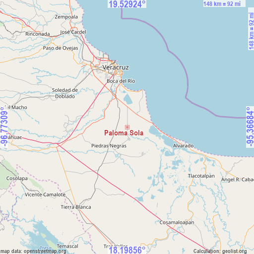
Paloma Sola GPS coordinates[2]
18° 51' 54.792" North, 96° 4' 11.856" West
| Map corner | latitude | longitude |
|---|---|---|
| Upper-left | 19.52924°, | -96.77309° |
| Center: | 18.86522°, | -96.06996° |
| Lower-right: | 18.19856°, | -95.36684° |
| Map W x H: | 148×148 km | = 92×92mi |
| max Lat: | 32.7° ⇑67.7% North |
| Paloma Sola: | 18.86522° |
| min Lat: | ⇓32.3% South 14.53588° |
| min Long | Paloma Sola | max Long |
| -117.105° | -96.06996° | -86.73105° |
| W 82%⇐ | ⇒18% E |
Elevation
Elevation of Paloma Sola is 19 m = 62 ft, and this is 1234.7 m = 4051 ft below average elevation for this country.
| Max E: |
3497 m = 11473 ft | 92.1% |
| Avg. | 1253.7 m = 4113 ft | |
| Paloma Sola | 19 m = 62 ft | |
Min E: |
-1 m = -3 ft | 7.9% |
See also: Mexico elevation on elevation.city.
Geographical zone
Paloma Sola is located in North Torrid zone (between Equator and Tropic of Cancer). Distance of this Northern Tropic circle is 508.3 km =315.8 mi to North.| Distance of | km | miles | from Paloma Sola |
|---|---|---|---|
| North Pole | 7909.4 | 4914.7 | to North |
| Arctic Circle | 5303.6 | 3295.5 | to North |
| Tropic Cancer | 508.3 | 315.8 | to North |
| Equator | 2097.6 | 1303.4 | to South |


Nearby cities:
15 places around Paloma Sola: (largest is in red/bold)
• El Bayo
16.9 km =10.5 mi,  38°
38°
• El Cocuite
16.5 km =10.3 mi,  185°
185°
• El Sauce (Cerro Grande)
17 km =10.6 mi,  179°
179°
• El Zapote
12.1 km =7.5 mi,  208°
208°
• Herón Proal
16.7 km =10.4 mi,  350°
350°
• La Laguna y Monte del Castillo
13.2 km =8.2 mi,  356°
356°
• La Piedra
9.8 km =6.1 mi, 36°
• Los Robles
13 km =8.1 mi,  337°
337°
• Mata Cabestro (La Víbora)
5.4 km =3.4 mi,  0°
0°
• Moyotla
17 km =10.6 mi,  159°
159°
• Piedras Negras
15 km =9.3 mi,  225°
225°
• Pozuelo
4.2 km =2.6 mi, 188°
• Salinas
13.6 km =8.5 mi,  78°
78°
• Tlalixcoyan
7.1 km =4.4 mi,  171°
171°
• Tuzales
9.9 km =6.2 mi,  197°
197°
Sources, notices
• [Note1] Compared only with cities in Mexico existing in our database
• [Src1] Map data: © OpenStreetMap contributors (CC-BY-SA)
• [Src2] Other city data from geonames.org with taken over terms of usage.
• [Src3] Geographical zone / Annual Mean Temperature by Robert A. Rohde @ Wikipedia
