Puyecaco geodata
Puyecaco (Veracruz) is a populated place; located in Mexico in America/Mexico_City (GMT-6) time zone. With population of 578 people, there are 14828 cities with bigger population in this country. Compared to other cities in Mexico, 72.6% of cities are located further ↓South; 63.1% of cities are located further ←West and 76.4% of cities have higher elevation than Puyecaco. Note1


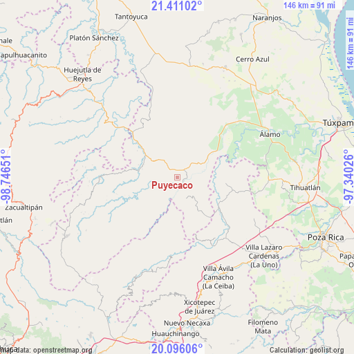
Puyecaco GPS coordinates[2]
20° 45' 17.892" North, 98° 2' 36.168" West
| Map corner | latitude | longitude |
|---|---|---|
| Upper-left | 21.41102°, | -98.74651° |
| Center: | 20.75497°, | -98.04338° |
| Lower-right: | 20.09606°, | -97.34026° |
| Map W x H: | 146.2×146.2 km | = 90.8×90.8mi |
| max Lat: | 32.7° ⇑27.4% North |
| Puyecaco: | 20.75497° |
| min Lat: | ⇓72.6% South 14.53588° |
| min Long | Puyecaco | max Long |
| -117.105° | -98.04338° | -86.73105° |
| W 63.1%⇐ | ⇒36.9% E |
Elevation
Elevation of Puyecaco is 172 m = 564 ft, and this is 1081.7 m = 3549 ft below average elevation for this country.
| Max E: |
3497 m = 11473 ft | 76.4% |
| Avg. | 1253.7 m = 4113 ft | |
| Puyecaco | 172 m = 564 ft | |
Min E: |
-1 m = -3 ft | 23.6% |
See also: Mexico elevation on elevation.city.
Geographical zone
Puyecaco is located in North Torrid zone (between Equator and Tropic of Cancer). Distance of this Northern Tropic circle is 298.2 km =185.3 mi to North.| Distance of | km | miles | from Puyecaco |
|---|---|---|---|
| North Pole | 7699.3 | 4784.1 | to North |
| Arctic Circle | 5093.4 | 3164.9 | to North |
| Tropic Cancer | 298.2 | 185.3 | to North |
| Equator | 2307.7 | 1433.9 | to South |


Nearby cities:
15 places around Puyecaco: (largest is in red/bold)
• Ayolia
10.1 km =6.3 mi,  33°
33°
• Cacahuatengo
3.4 km =2.1 mi,  6°
6°
• Colatlán
8.8 km =5.5 mi,  320°
320°
• El Limón
9.2 km =5.7 mi,  355°
355°
• El Tizán
2.7 km =1.7 mi,  288°
288°
• Huexotitla
5 km =3.1 mi, 289°
• Ixhuatlán de Madero
8.1 km =5 mi,  155°
155°
• Joya Chica
6.8 km =4.2 mi,  136°
136°
• Llano de Enmedio
4.4 km =2.7 mi,  44°
44°
• Lomas del Dorado
9 km =5.6 mi,  48°
48°
• Ojital Cuayo
10.1 km =6.3 mi,  119°
119°
• Palma Real
11.1 km =6.9 mi,  300°
300°
• Piedra Grande
2.8 km =1.7 mi,  0°
0°
• Pilpuerta
8.4 km =5.2 mi, 289°
• Tenantitla
10.6 km =6.6 mi,  279°
279°
Sources, notices
• [Note1] Compared only with cities in Mexico existing in our database
• [Src1] Map data: © OpenStreetMap contributors (CC-BY-SA)
• [Src2] Other city data from geonames.org with taken over terms of usage.
• [Src3] Geographical zone / Annual Mean Temperature by Robert A. Rohde @ Wikipedia
