Palma Real geodata
Palma Real (Veracruz) is a populated place; located in Mexico in America/Mexico_City (GMT-6) time zone. With population of 621 people, there are 13905 cities with bigger population in this country. Compared to other cities in Mexico, 73.4% of cities are located further ↓South; 62.1% of cities are located further ←West and 71.9% of cities have higher elevation than Palma Real. Note1


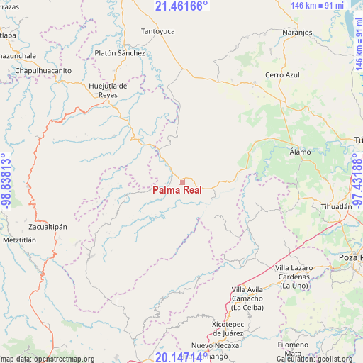
Palma Real GPS coordinates[2]
20° 48' 20.988" North, 98° 8' 6" West
| Map corner | latitude | longitude |
|---|---|---|
| Upper-left | 21.46166°, | -98.83813° |
| Center: | 20.80583°, | -98.135° |
| Lower-right: | 20.14714°, | -97.43188° |
| Map W x H: | 146.2×146.2 km | = 90.8×90.8mi |
| max Lat: | 32.7° ⇑26.6% North |
| Palma Real: | 20.80583° |
| min Lat: | ⇓73.4% South 14.53588° |
| min Long | Palma Real | max Long |
| -117.105° | -98.135° | -86.73105° |
| W 62.1%⇐ | ⇒37.9% E |
Elevation
Elevation of Palma Real is 332 m = 1089 ft, and this is 921.7 m = 3024 ft below average elevation for this country.
| Max E: |
3497 m = 11473 ft | 71.9% |
| Avg. | 1253.7 m = 4113 ft | |
| Palma Real | 332 m = 1089 ft | |
Min E: |
-1 m = -3 ft | 28.1% |
See also: Mexico elevation on elevation.city.
Geographical zone
Palma Real is located in North Torrid zone (between Equator and Tropic of Cancer). Distance of this Northern Tropic circle is 292.5 km =181.8 mi to North.| Distance of | km | miles | from Palma Real |
|---|---|---|---|
| North Pole | 7693.7 | 4780.6 | to North |
| Arctic Circle | 5087.8 | 3161.4 | to North |
| Tropic Cancer | 292.5 | 181.8 | to North |
| Equator | 2313.4 | 1437.5 | to South |


Nearby cities:
15 places around Palma Real: (largest is in red/bold)
• Cacahuatengo
10.1 km =6.3 mi,  102°
102°
• Calaco
10.4 km =6.5 mi,  329°
329°
• Colatlán
4.1 km =2.5 mi,  73°
73°
• El Limón
9.5 km =5.9 mi, 68°
• El Naranjal
9 km =5.6 mi,  200°
200°
• El Tizán
8.5 km =5.3 mi,  124°
124°
• Huexotitla
6.3 km =3.9 mi,  129°
129°
• Hueycuatitla
8.1 km =5 mi, 328°
• La Reforma
1.6 km =1 mi,  316°
316°
• Otlamalacatl
9.7 km =6 mi,  288°
288°
• Piedra Grande
10 km =6.2 mi,  106°
106°
• Pilpuerta
3.3 km =2.1 mi,  149°
149°
• Primo Verdad
8.5 km =5.3 mi,  282°
282°
• Tenantitla
4.1 km =2.5 mi,  193°
193°
• Xochimilco
9.3 km =5.8 mi,  46°
46°
Sources, notices
• [Note1] Compared only with cities in Mexico existing in our database
• [Src1] Map data: © OpenStreetMap contributors (CC-BY-SA)
• [Src2] Other city data from geonames.org with taken over terms of usage.
• [Src3] Geographical zone / Annual Mean Temperature by Robert A. Rohde @ Wikipedia
