Joya Chica geodata
Joya Chica (Veracruz) is a populated place; located in Mexico in America/Mexico_City (GMT-6) time zone. With population of 563 people, there are 15167 cities with bigger population in this country. Compared to other cities in Mexico, 71.8% of cities are located further ↓South; 63.6% of cities are located further ←West and 76.6% of cities have higher elevation than Joya Chica. Note1


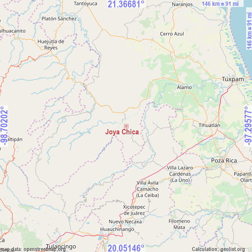
Joya Chica GPS coordinates[2]
20° 42' 38.016" North, 97° 59' 56.004" West
| Map corner | latitude | longitude |
|---|---|---|
| Upper-left | 21.36681°, | -98.70202° |
| Center: | 20.71056°, | -97.99889° |
| Lower-right: | 20.05146°, | -97.29577° |
| Map W x H: | 146.3×146.3 km | = 90.9×90.9mi |
| max Lat: | 32.7° ⇑28.2% North |
| Joya Chica: | 20.71056° |
| min Lat: | ⇓71.8% South 14.53588° |
| min Long | Joya Chica | max Long |
| -117.105° | -97.99889° | -86.73105° |
| W 63.6%⇐ | ⇒36.4% E |
Elevation
Elevation of Joya Chica is 167 m = 548 ft, and this is 1086.7 m = 3565 ft below average elevation for this country.
| Max E: |
3497 m = 11473 ft | 76.6% |
| Avg. | 1253.7 m = 4113 ft | |
| Joya Chica | 167 m = 548 ft | |
Min E: |
-1 m = -3 ft | 23.4% |
See also: Mexico elevation on elevation.city.
Geographical zone
Joya Chica is located in North Torrid zone (between Equator and Tropic of Cancer). Distance of this Northern Tropic circle is 303.1 km =188.3 mi to North.| Distance of | km | miles | from Joya Chica |
|---|---|---|---|
| North Pole | 7704.3 | 4787.2 | to North |
| Arctic Circle | 5098.4 | 3168 | to North |
| Tropic Cancer | 303.1 | 188.3 | to North |
| Equator | 2302.8 | 1430.9 | to South |


Nearby cities:
15 places around Joya Chica: (largest is in red/bold)
• Ayolia
13.5 km =8.4 mi,  3°
3°
• Cacahuatengo
9.4 km =5.8 mi,  332°
332°
• El Tizán
9.2 km =5.7 mi,  308°
308°
• El Zapote Bravo
5.4 km =3.4 mi,  180°
180°
• Huexotitla
11.4 km =7.1 mi, 305°
• Ixhuatlán de Madero
2.8 km =1.7 mi,  208°
208°
• Jonotal Azteca
11.9 km =7.4 mi,  248°
248°
• Llano de Enmedio
8.2 km =5.1 mi,  349°
349°
• Lomas del Dorado
11.1 km =6.9 mi,  10°
10°
• Ojital Cuayo
4.1 km =2.5 mi,  90°
90°
• Piedra Grande
9 km =5.6 mi, 329°
• Pisaflores
13.5 km =8.4 mi,  146°
146°
• Puyecaco
6.8 km =4.2 mi,  316°
316°
• San Martín
6.5 km =4 mi,  105°
105°
• Tzocohuite
13.8 km =8.6 mi,  31°
31°
Sources, notices
• [Note1] Compared only with cities in Mexico existing in our database
• [Src1] Map data: © OpenStreetMap contributors (CC-BY-SA)
• [Src2] Other city data from geonames.org with taken over terms of usage.
• [Src3] Geographical zone / Annual Mean Temperature by Robert A. Rohde @ Wikipedia
