Cacahuatengo geodata
Cacahuatengo (Veracruz) is a populated place; located in Mexico in America/Mexico_City (GMT-6) time zone. With population of 726 people, there are 12023 cities with bigger population in this country. Compared to other cities in Mexico, 73.1% of cities are located further ↓South; 63.1% of cities are located further ←West and 76.1% of cities have higher elevation than Cacahuatengo. Note1


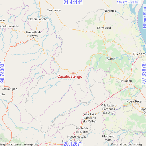
Cacahuatengo GPS coordinates[2]
20° 47' 7.728" North, 98° 2' 23.64" West
| Map corner | latitude | longitude |
|---|---|---|
| Upper-left | 21.4414°, | -98.74303° |
| Center: | 20.78548°, | -98.0399° |
| Lower-right: | 20.1267°, | -97.33678° |
| Map W x H: | 146.2×146.2 km | = 90.8×90.8mi |
| max Lat: | 32.7° ⇑26.9% North |
| Cacahuatengo: | 20.78548° |
| min Lat: | ⇓73.1% South 14.53588° |
| min Long | Cacahuatengo | max Long |
| -117.105° | -98.0399° | -86.73105° |
| W 63.1%⇐ | ⇒36.9% E |
Elevation
Elevation of Cacahuatengo is 183 m = 600 ft, and this is 1070.7 m = 3513 ft below average elevation for this country.
| Max E: |
3497 m = 11473 ft | 76.1% |
| Avg. | 1253.7 m = 4113 ft | |
| Cacahuatengo | 183 m = 600 ft | |
Min E: |
-1 m = -3 ft | 23.9% |
See also: Mexico elevation on elevation.city.
Geographical zone
Cacahuatengo is located in North Torrid zone (between Equator and Tropic of Cancer). Distance of this Northern Tropic circle is 294.8 km =183.2 mi to North.| Distance of | km | miles | from Cacahuatengo |
|---|---|---|---|
| North Pole | 7695.9 | 4782 | to North |
| Arctic Circle | 5090 | 3162.8 | to North |
| Tropic Cancer | 294.8 | 183.2 | to North |
| Equator | 2311.1 | 1436.1 | to South |


Nearby cities:
15 places around Cacahuatengo: (largest is in red/bold)
• Ayolia
7.3 km =4.5 mi,  45°
45°
• Colatlán
6.9 km =4.3 mi,  300°
300°
• El Limón
5.9 km =3.7 mi,  349°
349°
• El Tizán
3.8 km =2.4 mi,  228°
228°
• Huexotitla
5.4 km =3.4 mi,  251°
251°
• Joya Chica
9.4 km =5.8 mi,  152°
152°
• Llano de Enmedio
2.7 km =1.7 mi,  95°
95°
• Lomas del Dorado
6.8 km =4.2 mi,  67°
67°
• Palma Real
10.1 km =6.3 mi,  282°
282°
• Piedra Grande
0.7 km =0.4 mi,  209°
209°
• Pilpuerta
8.3 km =5.2 mi,  266°
266°
• Puyecaco
3.4 km =2.1 mi,  186°
186°
• Reyixtla
10.1 km =6.3 mi, 350°
• Tenantitla
11 km =6.8 mi,  261°
261°
• Xochimilco
9.2 km =5.7 mi,  340°
340°
Sources, notices
• [Note1] Compared only with cities in Mexico existing in our database
• [Src1] Map data: © OpenStreetMap contributors (CC-BY-SA)
• [Src2] Other city data from geonames.org with taken over terms of usage.
• [Src3] Geographical zone / Annual Mean Temperature by Robert A. Rohde @ Wikipedia
