San Felipe geodata
San Felipe (Oaxaca) is a populated place; located in Mexico in America/Mexico_City (GMT-6) time zone. With population of 702 people, there are 12396 cities with bigger population in this country. Compared to other cities in Mexico, 80.1% of cities are located further ↑North; 82.4% of cities are located further ←West and 77.3% of cities have higher elevation than San Felipe. Note1


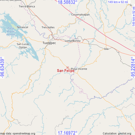
San Felipe GPS coordinates[2]
17° 50' 25.008" North, 95° 55' 52.536" West
| Map corner | latitude | longitude |
|---|---|---|
| Upper-left | 18.50832°, | -96.63439° |
| Center: | 17.84028°, | -95.93126° |
| Lower-right: | 17.16972°, | -95.22814° |
| Map W x H: | 148.8×148.8 km | = 92.5×92.5mi |
| max Lat: | 32.7° ⇑80.1% North |
| San Felipe: | 17.84028° |
| min Lat: | ⇓19.9% South 14.53588° |
| min Long | San Felipe | max Long |
| -117.105° | -95.93126° | -86.73105° |
| W 82.4%⇐ | ⇒17.6% E |
Elevation
Elevation of San Felipe is 145 m = 476 ft, and this is 1108.7 m = 3637 ft below average elevation for this country.
| Max E: |
3497 m = 11473 ft | 77.3% |
| Avg. | 1253.7 m = 4113 ft | |
| San Felipe | 145 m = 476 ft | |
Min E: |
-1 m = -3 ft | 22.7% |
See also: Mexico elevation on elevation.city.
Geographical zone
San Felipe is located in North Torrid zone (between Equator and Tropic of Cancer). Distance of this Northern Tropic circle is 622.3 km =386.7 mi to North.| Distance of | km | miles | from San Felipe |
|---|---|---|---|
| North Pole | 8023.4 | 4985.5 | to North |
| Arctic Circle | 5417.5 | 3366.3 | to North |
| Tropic Cancer | 622.3 | 386.7 | to North |
| Equator | 1983.7 | 1232.6 | to South |


Nearby cities:
15 places around San Felipe: (largest is in red/bold)
• Arenal Santa Ana
18 km =11.2 mi,  108°
108°
• Arroyo Limón
7.4 km =4.6 mi,  334°
334°
• Arroyo Metate
18.5 km =11.5 mi,  0°
0°
• Bethania
11.7 km =7.3 mi,  318°
318°
• Camalotal
17 km =10.6 mi, 321°
• Chilapa del Carmen
14.7 km =9.1 mi,  115°
115°
• Esperanza Arroyo la Gloria
14.6 km =9.1 mi,  341°
341°
• La Carlota
5.9 km =3.7 mi,  87°
87°
• La Soledad
6.6 km =4.1 mi,  63°
63°
• Mixtán
10.9 km =6.8 mi,  43°
43°
• Playa Vicente
12.7 km =7.9 mi, 94°
• Pueblo Nuevo Ojo de Agua
6.1 km =3.8 mi,  13°
13°
• Pueblo Viejo
15.3 km =9.5 mi,  299°
299°
• San Benito Encinal
16.5 km =10.3 mi, 7°
• Tomate Río Manso
13.4 km =8.3 mi,  152°
152°
Sources, notices
• [Note1] Compared only with cities in Mexico existing in our database
• [Src1] Map data: © OpenStreetMap contributors (CC-BY-SA)
• [Src2] Other city data from geonames.org with taken over terms of usage.
• [Src3] Geographical zone / Annual Mean Temperature by Robert A. Rohde @ Wikipedia
