Piedra Ancha geodata
Piedra Ancha (Guerrero) is a populated place; located in Mexico in America/Mexico_City (GMT-6) time zone. With population of 552 people, there are 15449 cities with bigger population in this country. Compared to other cities in Mexico, 93.7% of cities are located further ↑North; 59.1% of cities are located further ←West and 73.8% of cities have higher elevation than Piedra Ancha. Note1


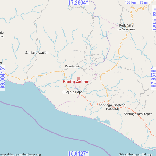
Piedra Ancha GPS coordinates[2]
16° 35' 15.828" North, 98° 21' 39.672" West
| Map corner | latitude | longitude |
|---|---|---|
| Upper-left | 17.2604°, | -99.06415° |
| Center: | 16.58773°, | -98.36102° |
| Lower-right: | 15.9127°, | -97.6579° |
| Map W x H: | 149.9×149.9 km | = 93.1×93.1mi |
| max Lat: | 32.7° ⇑93.7% North |
| Piedra Ancha: | 16.58773° |
| min Lat: | ⇓6.3% South 14.53588° |
| min Long | Piedra Ancha | max Long |
| -117.105° | -98.36102° | -86.73105° |
| W 59.1%⇐ | ⇒40.9% E |
Elevation
Elevation of Piedra Ancha is 264 m = 866 ft, and this is 989.7 m = 3247 ft below average elevation for this country.
| Max E: |
3497 m = 11473 ft | 73.8% |
| Avg. | 1253.7 m = 4113 ft | |
| Piedra Ancha | 264 m = 866 ft | |
Min E: |
-1 m = -3 ft | 26.2% |
See also: Mexico elevation on elevation.city.
Geographical zone
Piedra Ancha is located in North Torrid zone (between Equator and Tropic of Cancer). Distance of this Northern Tropic circle is 761.5 km =473.2 mi to North.| Distance of | km | miles | from Piedra Ancha |
|---|---|---|---|
| North Pole | 8162.7 | 5072.1 | to North |
| Arctic Circle | 5556.8 | 3452.8 | to North |
| Tropic Cancer | 761.5 | 473.2 | to North |
| Equator | 1844.4 | 1146.1 | to South |


Nearby cities:
15 places around Piedra Ancha: (largest is in red/bold)
• Barajillas (Barajilla)
14.1 km =8.8 mi,  231°
231°
• Comaltepec
11.8 km =7.3 mi,  266°
266°
• Cruz Verde II
14.2 km =8.8 mi,  30°
30°
• Cuajinicuilapa
13.9 km =8.6 mi,  203°
203°
• El Quiza
8.6 km =5.3 mi,  213°
213°
• El Terrero
8.8 km =5.5 mi,  251°
251°
• Huixtepec
9.5 km =5.9 mi,  39°
39°
• La Concepción
13.5 km =8.4 mi,  53°
53°
• Milpillas
10.6 km =6.6 mi, 266°
• Mártires de Tacubaya
12.7 km =7.9 mi,  115°
115°
• Ometepec
12.4 km =7.7 mi,  336°
336°
• San Francisco del Maguey
10.5 km =6.5 mi,  144°
144°
• San Juan Bautista Lo de Soto
8.5 km =5.3 mi,  170°
170°
• Santiago Llano Grande
13.4 km =8.3 mi,  145°
145°
• Tierra Blanca
4.8 km =3 mi,  58°
58°
Sources, notices
• [Note1] Compared only with cities in Mexico existing in our database
• [Src1] Map data: © OpenStreetMap contributors (CC-BY-SA)
• [Src2] Other city data from geonames.org with taken over terms of usage.
• [Src3] Geographical zone / Annual Mean Temperature by Robert A. Rohde @ Wikipedia
