Huixtepec geodata
Huixtepec (Guerrero) is a populated place; located in Mexico in America/Mexico_City (GMT-6) time zone. With population of 3,370 people, there are 2695 cities with bigger population in this country. Compared to other cities in Mexico, 93.2% of cities are located further ↑North; 59.8% of cities are located further ←West and 71% of cities have higher elevation than Huixtepec. Note1


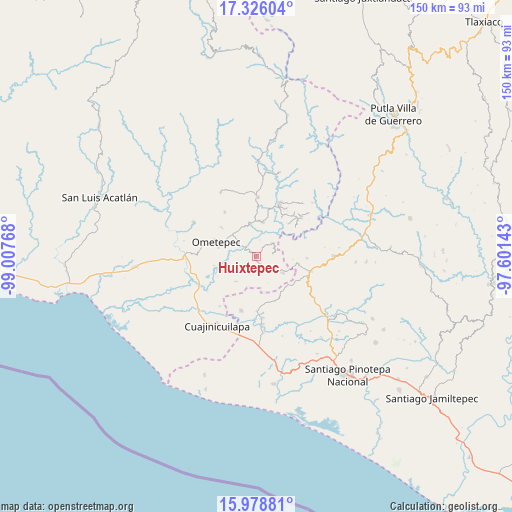
Huixtepec GPS coordinates[2]
16° 39' 12.996" North, 98° 18' 16.38" West
| Map corner | latitude | longitude |
|---|---|---|
| Upper-left | 17.32604°, | -99.00768° |
| Center: | 16.65361°, | -98.30455° |
| Lower-right: | 15.97881°, | -97.60143° |
| Map W x H: | 149.8×149.8 km | = 93.1×93.1mi |
| max Lat: | 32.7° ⇑93.2% North |
| Huixtepec: | 16.65361° |
| min Lat: | ⇓6.8% South 14.53588° |
| min Long | Huixtepec | max Long |
| -117.105° | -98.30455° | -86.73105° |
| W 59.8%⇐ | ⇒40.2% E |
Elevation
Elevation of Huixtepec is 371 m = 1217 ft, and this is 882.7 m = 2896 ft below average elevation for this country.
| Max E: |
3497 m = 11473 ft | 71% |
| Avg. | 1253.7 m = 4113 ft | |
| Huixtepec | 371 m = 1217 ft | |
Min E: |
-1 m = -3 ft | 29% |
See also: Mexico elevation on elevation.city.
Geographical zone
Huixtepec is located in North Torrid zone (between Equator and Tropic of Cancer). Distance of this Northern Tropic circle is 754.2 km =468.6 mi to North.| Distance of | km | miles | from Huixtepec |
|---|---|---|---|
| North Pole | 8155.4 | 5067.5 | to North |
| Arctic Circle | 5549.5 | 3448.3 | to North |
| Tropic Cancer | 754.2 | 468.6 | to North |
| Equator | 1851.7 | 1150.6 | to South |


Nearby cities:
15 places around Huixtepec: (largest is in red/bold)
• Buenavista
12 km =7.5 mi,  99°
99°
• Cochoapa
10.5 km =6.5 mi,  316°
316°
• Cruz Verde II
5.1 km =3.2 mi,  12°
12°
• Cumbre de Barranca Honda
9.3 km =5.8 mi,  338°
338°
• Huajintepec
9.3 km =5.8 mi,  121°
121°
• La Concepción
4.9 km =3 mi,  80°
80°
• La Guadalupe
6 km =3.7 mi,  49°
49°
• La Soledad
13.6 km =8.5 mi,  309°
309°
• Los Liros
13.3 km =8.3 mi,  44°
44°
• Ometepec
11.7 km =7.3 mi,  290°
290°
• Piedra Ancha
9.5 km =5.9 mi,  219°
219°
• Plan de los Muertos
13.5 km =8.4 mi,  33°
33°
• Tierra Blanca
5.2 km =3.2 mi,  201°
201°
• Villa Hidalgo
12.8 km =8 mi, 309°
• Zacoalpan
10.3 km =6.4 mi, 10°
Sources, notices
• [Note1] Compared only with cities in Mexico existing in our database
• [Src1] Map data: © OpenStreetMap contributors (CC-BY-SA)
• [Src2] Other city data from geonames.org with taken over terms of usage.
• [Src3] Geographical zone / Annual Mean Temperature by Robert A. Rohde @ Wikipedia
