Cruz Verde II geodata
Cruz Verde II (Guerrero) is a populated place; located in Mexico in America/Mexico_City (GMT-6) time zone. With population of 587 people, there are 14622 cities with bigger population in this country. Compared to other cities in Mexico, 92.8% of cities are located further ↑North; 59.9% of cities are located further ←West and 72.4% of cities have higher elevation than Cruz Verde II. Note1


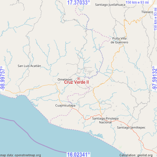
Cruz Verde II GPS coordinates[2]
16° 41' 53.016" North, 98° 17' 39.984" West
| Map corner | latitude | longitude |
|---|---|---|
| Upper-left | 17.37033°, | -98.99757° |
| Center: | 16.69806°, | -98.29444° |
| Lower-right: | 16.02341°, | -97.59132° |
| Map W x H: | 149.8×149.8 km | = 93.1×93.1mi |
| max Lat: | 32.7° ⇑92.8% North |
| Cruz Verde II: | 16.69806° |
| min Lat: | ⇓7.2% South 14.53588° |
| min Long | Cruz Verde II | max Long |
| -117.105° | -98.29444° | -86.73105° |
| W 59.9%⇐ | ⇒40.1% E |
Elevation
Elevation of Cruz Verde II is 316 m = 1037 ft, and this is 937.7 m = 3076 ft below average elevation for this country.
| Max E: |
3497 m = 11473 ft | 72.4% |
| Avg. | 1253.7 m = 4113 ft | |
| Cruz Verde II | 316 m = 1037 ft | |
Min E: |
-1 m = -3 ft | 27.6% |
See also: Mexico elevation on elevation.city.
Geographical zone
Cruz Verde II is located in North Torrid zone (between Equator and Tropic of Cancer). Distance of this Northern Tropic circle is 749.3 km =465.6 mi to North.| Distance of | km | miles | from Cruz Verde II |
|---|---|---|---|
| North Pole | 8150.4 | 5064.4 | to North |
| Arctic Circle | 5544.5 | 3445.2 | to North |
| Tropic Cancer | 749.3 | 465.6 | to North |
| Equator | 1856.7 | 1153.7 | to South |


Nearby cities:
15 places around Cruz Verde II: (largest is in red/bold)
• Arroyo Gente
10.9 km =6.8 mi,  71°
71°
• Cochoapa
8.7 km =5.4 mi,  287°
287°
• Cumbre de Barranca Honda
5.8 km =3.6 mi,  309°
309°
• El Santiago
11.7 km =7.3 mi,  53°
53°
• Huajintepec
11.9 km =7.4 mi,  145°
145°
• Huixtepec
5.1 km =3.2 mi,  192°
192°
• La Concepción
5.6 km =3.5 mi,  137°
137°
• La Guadalupe
3.6 km =2.2 mi,  106°
106°
• Los Liros
9.4 km =5.8 mi,  60°
60°
• Ometepec
12.1 km =7.5 mi,  265°
265°
• Plan de los Muertos
9 km =5.6 mi,  44°
44°
• Tierra Blanca
10.2 km =6.3 mi,  197°
197°
• Villa Hidalgo
11.4 km =7.1 mi, 285°
• Xochistlahuaca
12.1 km =7.5 mi,  27°
27°
• Zacoalpan
5.3 km =3.3 mi,  7°
7°
Sources, notices
• [Note1] Compared only with cities in Mexico existing in our database
• [Src1] Map data: © OpenStreetMap contributors (CC-BY-SA)
• [Src2] Other city data from geonames.org with taken over terms of usage.
• [Src3] Geographical zone / Annual Mean Temperature by Robert A. Rohde @ Wikipedia
