Palmas de Abajo geodata
Palmas de Abajo (Veracruz) is a populated place; located in Mexico in America/Mexico_City (GMT-6) time zone. With population of 1,014 people, there are 8595 cities with bigger population in this country. Compared to other cities in Mexico, 52.1% of cities are located further ↑North; 80% of cities are located further ←West and 82.2% of cities have higher elevation than Palmas de Abajo. Note1


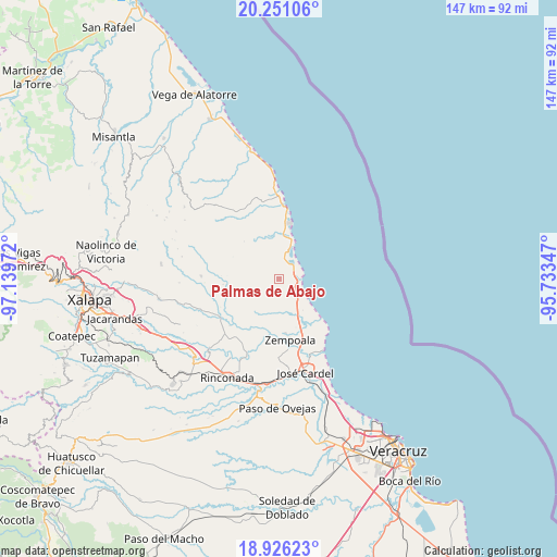
Palmas de Abajo GPS coordinates[2]
19° 35' 24.036" North, 96° 26' 11.724" West
| Map corner | latitude | longitude |
|---|---|---|
| Upper-left | 20.25106°, | -97.13972° |
| Center: | 19.59001°, | -96.43659° |
| Lower-right: | 18.92623°, | -95.73347° |
| Map W x H: | 147.3×147.3 km | = 91.5×91.5mi |
| max Lat: | 32.7° ⇑52.1% North |
| Palmas de Abajo: | 19.59001° |
| min Lat: | ⇓47.9% South 14.53588° |
| min Long | Palmas de Abajo | max Long |
| -117.105° | -96.43659° | -86.73105° |
| W 80%⇐ | ⇒20% E |
Elevation
Elevation of Palmas de Abajo is 68 m = 223 ft, and this is 1185.7 m = 3890 ft below average elevation for this country.
| Max E: |
3497 m = 11473 ft | 82.2% |
| Avg. | 1253.7 m = 4113 ft | |
| Palmas de Abajo | 68 m = 223 ft | |
Min E: |
-1 m = -3 ft | 17.8% |
See also: Mexico elevation on elevation.city.
Geographical zone
Palmas de Abajo is located in North Torrid zone (between Equator and Tropic of Cancer). Distance of this Northern Tropic circle is 427.7 km =265.8 mi to North.| Distance of | km | miles | from Palmas de Abajo |
|---|---|---|---|
| North Pole | 7828.9 | 4864.7 | to North |
| Arctic Circle | 5223 | 3245.4 | to North |
| Tropic Cancer | 427.7 | 265.8 | to North |
| Equator | 2178.2 | 1353.5 | to South |


Nearby cities:
15 places around Palmas de Abajo: (largest is in red/bold)
• El Chalahuite
14.7 km =9.1 mi,  153°
153°
• El Farallón
5.9 km =3.7 mi,  27°
27°
• El Viejón Nuevo
11.3 km =7 mi,  13°
13°
• El Zapotito
15.8 km =9.8 mi,  180°
180°
• Hornitos
14.5 km =9 mi,  173°
173°
• Jareros
16.4 km =10.2 mi,  193°
193°
• Mozomboa
10.4 km =6.5 mi,  204°
204°
• Paso de Doña Juana
15.1 km =9.4 mi, 146°
• Paso del Cedro
10.8 km =6.7 mi, 151°
• San Isidro
13.4 km =8.3 mi, 153°
• San José Pastorías
14.3 km =8.9 mi,  258°
258°
• Santa Rosa
13.6 km =8.5 mi, 192°
• Tinajitas
3.2 km =2 mi,  348°
348°
• Villa Zempoala
16.5 km =10.3 mi, 169°
• Zoyacuautla
14.8 km =9.2 mi, 264°
Sources, notices
• [Note1] Compared only with cities in Mexico existing in our database
• [Src1] Map data: © OpenStreetMap contributors (CC-BY-SA)
• [Src2] Other city data from geonames.org with taken over terms of usage.
• [Src3] Geographical zone / Annual Mean Temperature by Robert A. Rohde @ Wikipedia
