Oxchuc geodata
Oxchuc (Chiapas) is a seat of a second-order administrative division; located in Mexico in America/Mexico_City (GMT-6) time zone. With population of 6,675 people, there are 1404 cities with bigger population in this country. Compared to other cities in Mexico, 91.9% of cities are located further ↑North; 93.1% of cities are located further ←West and 72% of cities have lower elevation than Oxchuc. Note1


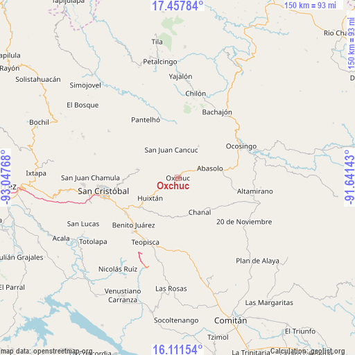
Oxchuc GPS coordinates[2]
16° 47' 9.168" North, 92° 20' 40.38" West
| Map corner | latitude | longitude |
|---|---|---|
| Upper-left | 17.45784°, | -93.04768° |
| Center: | 16.78588°, | -92.34455° |
| Lower-right: | 16.11154°, | -91.64143° |
| Map W x H: | 149.7×149.7 km | = 93×93mi |
| max Lat: | 32.7° ⇑91.9% North |
| Oxchuc: | 16.78588° |
| min Lat: | ⇓8.1% South 14.53588° |
| min Long | Oxchuc | max Long |
| -117.105° | -92.34455° | -86.73105° |
| W 93.1%⇐ | ⇒6.9% E |
Elevation
Elevation of Oxchuc is 1967 m = 6453 ft, and this is 713.3 m = 2340 ft above average elevation for this country.
| Max E: |
3497 m = 11473 ft | 28% |
| Oxchuc | 1967 m 6453 ft | |
| Avg. | 1253.7 m = 4113 ft | |
Min E: |
-1 m = -3 ft | 72% |
See also: Mexico elevation on elevation.city.
Geographical zone
Oxchuc is located in North Torrid zone (between Equator and Tropic of Cancer). Distance of this Northern Tropic circle is 739.5 km =459.5 mi to North.| Distance of | km | miles | from Oxchuc |
|---|---|---|---|
| North Pole | 8140.6 | 5058.3 | to North |
| Arctic Circle | 5534.8 | 3439.2 | to North |
| Tropic Cancer | 739.5 | 459.5 | to North |
| Equator | 1866.4 | 1159.7 | to South |


Nearby cities:
15 places around Oxchuc: (largest is in red/bold)
• Adolfo López Mateos
8.4 km =5.2 mi,  242°
242°
• Chanal
9.7 km =6 mi,  217°
217°
• Cruztón
6.4 km =4 mi,  6°
6°
• El Corralito
10.4 km =6.5 mi,  67°
67°
• El Retiro
2.2 km =1.4 mi,  301°
301°
• El Tzay
9.3 km =5.8 mi,  21°
21°
• La Frontera
9 km =5.6 mi,  319°
319°
• La Independencia
6.8 km =4.2 mi,  177°
177°
• La Libertad
7.8 km =4.8 mi, 184°
• Lelenchij
9.3 km =5.8 mi,  310°
310°
• Puilja
10.7 km =6.6 mi,  99°
99°
• San Andrés Puerto Rico
11.5 km =7.1 mi,  212°
212°
• San Gregorio de las Casas
11.9 km =7.4 mi,  203°
203°
• Tzopilja
6.4 km =4 mi,  143°
143°
• Tzunún
6.8 km =4.2 mi,  331°
331°
Sources, notices
• [Note1] Compared only with cities in Mexico existing in our database
• [Src1] Map data: © OpenStreetMap contributors (CC-BY-SA)
• [Src2] Other city data from geonames.org with taken over terms of usage.
• [Src3] Geographical zone / Annual Mean Temperature by Robert A. Rohde @ Wikipedia
