Chanal geodata
Chanal (Chiapas) is a populated place; located in Mexico in America/Mexico_City (GMT-6) time zone. With population of 5,592 people, there are 1668 cities with bigger population in this country. Compared to other cities in Mexico, 92.7% of cities are located further ↑North; 92.8% of cities are located further ←West and 71.8% of cities have lower elevation than Chanal. Note1


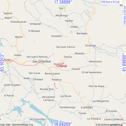
Chanal GPS coordinates[2]
16° 43' 0.012" North, 92° 24' 0" West
| Map corner | latitude | longitude |
|---|---|---|
| Upper-left | 17.38888°, | -93.10313° |
| Center: | 16.71667°, | -92.4° |
| Lower-right: | 16.04209°, | -91.69688° |
| Map W x H: | 149.7×149.8 km | = 93×93.1mi |
| max Lat: | 32.7° ⇑92.7% North |
| Chanal: | 16.71667° |
| min Lat: | ⇓7.3% South 14.53588° |
| min Long | Chanal | max Long |
| -117.105° | -92.4° | -86.73105° |
| W 92.8%⇐ | ⇒7.2% E |
Elevation
Elevation of Chanal is 1963 m = 6440 ft, and this is 709.3 m = 2327 ft above average elevation for this country.
| Max E: |
3497 m = 11473 ft | 28.2% |
| Chanal | 1963 m 6440 ft | |
| Avg. | 1253.7 m = 4113 ft | |
Min E: |
-1 m = -3 ft | 71.8% |
See also: Mexico elevation on elevation.city.
Geographical zone
Chanal is located in North Torrid zone (between Equator and Tropic of Cancer). Distance of this Northern Tropic circle is 747.2 km =464.3 mi to North.| Distance of | km | miles | from Chanal |
|---|---|---|---|
| North Pole | 8148.3 | 5063.1 | to North |
| Arctic Circle | 5542.5 | 3443.9 | to North |
| Tropic Cancer | 747.2 | 464.3 | to North |
| Equator | 1858.7 | 1154.9 | to South |


Nearby cities:
15 places around Chanal: (largest is in red/bold)
• Adolfo López Mateos
4.1 km =2.5 mi,  338°
338°
• Buenavista
6.5 km =4 mi,  211°
211°
• Carmen Yalchuch
8.9 km =5.5 mi,  153°
153°
• El Retiro
9.7 km =6 mi,  24°
24°
• Eshpuilho
8 km =5 mi,  265°
265°
• Huixtán
5.7 km =3.5 mi,  263°
263°
• Jocosic
8 km =5 mi,  310°
310°
• La Independencia
6.3 km =3.9 mi,  81°
81°
• La Libertad
5.2 km =3.2 mi,  90°
90°
• Los Pozos
7.7 km =4.8 mi,  185°
185°
• Oquem
8.4 km =5.2 mi,  275°
275°
• Oxchuc
9.7 km =6 mi,  37°
37°
• San Andrés Puerto Rico
2 km =1.2 mi, 189°
• San Gregorio de las Casas
3.5 km =2.2 mi,  159°
159°
• San José Yashitinín
8.4 km =5.2 mi, 214°
Sources, notices
• [Note1] Compared only with cities in Mexico existing in our database
• [Src1] Map data: © OpenStreetMap contributors (CC-BY-SA)
• [Src2] Other city data from geonames.org with taken over terms of usage.
• [Src3] Geographical zone / Annual Mean Temperature by Robert A. Rohde @ Wikipedia
