La Independencia geodata
La Independencia (Chiapas) is a populated place; located in Mexico in America/Mexico_City (GMT-6) time zone. With population of 576 people, there are 14877 cities with bigger population in this country. Compared to other cities in Mexico, 92.6% of cities are located further ↑North; 93.1% of cities are located further ←West and 69.5% of cities have lower elevation than La Independencia. Note1


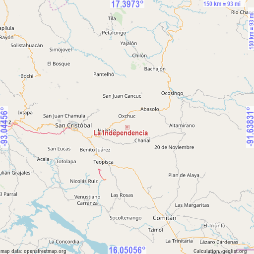
La Independencia GPS coordinates[2]
16° 43' 30.432" North, 92° 20' 29.148" West
| Map corner | latitude | longitude |
|---|---|---|
| Upper-left | 17.3973°, | -93.04456° |
| Center: | 16.72512°, | -92.34143° |
| Lower-right: | 16.05056°, | -91.63831° |
| Map W x H: | 149.7×149.7 km | = 93×93mi |
| max Lat: | 32.7° ⇑92.6% North |
| La Independencia: | 16.72512° |
| min Lat: | ⇓7.4% South 14.53588° |
| min Long | La Independenci | max Long |
| -117.105° | -92.34143° | -86.73105° |
| W 93.1%⇐ | ⇒6.9% E |
Elevation
Elevation of La Independencia is 1916 m = 6286 ft, and this is 662.3 m = 2173 ft above average elevation for this country.
| Max E: |
3497 m = 11473 ft | 30.5% |
| La Independencia | 1916 m 6286 ft | |
| Avg. | 1253.7 m = 4113 ft | |
Min E: |
-1 m = -3 ft | 69.5% |
See also: Mexico elevation on elevation.city.
Geographical zone
La Independencia is located in North Torrid zone (between Equator and Tropic of Cancer). Distance of this Northern Tropic circle is 746.3 km =463.7 mi to North.| Distance of | km | miles | from La Independencia |
|---|---|---|---|
| North Pole | 8147.4 | 5062.6 | to North |
| Arctic Circle | 5541.5 | 3443.3 | to North |
| Tropic Cancer | 746.3 | 463.7 | to North |
| Equator | 1859.7 | 1155.6 | to South |


Nearby cities:
15 places around La Independencia: (largest is in red/bold)
• Adolfo López Mateos
8.3 km =5.2 mi,  290°
290°
• Carmen Yalchuch
9.2 km =5.7 mi,  194°
194°
• Chanal
6.3 km =3.9 mi,  261°
261°
• El Retiro
8.2 km =5.1 mi,  344°
344°
• Guadalupe Bacja
9.5 km =5.9 mi,  98°
98°
• La Libertad
1.4 km =0.9 mi,  225°
225°
• Los Pozos
11.1 km =6.9 mi,  219°
219°
• Oxchuc
6.8 km =4.2 mi,  357°
357°
• Puilja
11.4 km =7.1 mi,  63°
63°
• Rancho del Cura
9.8 km =6.1 mi,  89°
89°
• San Andrés Puerto Rico
7.2 km =4.5 mi,  246°
246°
• San Fernando
7 km =4.3 mi,  134°
134°
• San Gregorio de las Casas
6.6 km =4.1 mi, 230°
• San Pedro Pedernal
7.1 km =4.4 mi,  163°
163°
• Tzopilja
3.8 km =2.4 mi, 64°
Sources, notices
• [Note1] Compared only with cities in Mexico existing in our database
• [Src1] Map data: © OpenStreetMap contributors (CC-BY-SA)
• [Src2] Other city data from geonames.org with taken over terms of usage.
• [Src3] Geographical zone / Annual Mean Temperature by Robert A. Rohde @ Wikipedia
