Cruztón geodata
Cruztón (Chiapas) is a populated place; located in Mexico in America/Mexico_City (GMT-6) time zone. With population of 705 people, there are 12337 cities with bigger population in this country. Compared to other cities in Mexico, 91.1% of cities are located further ↑North; 93.1% of cities are located further ←West and 59.6% of cities have lower elevation than Cruztón. Note1


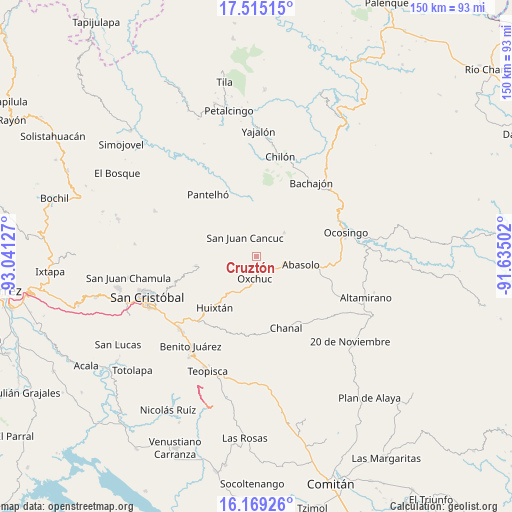
Cruztón GPS coordinates[2]
16° 50' 36.24" North, 92° 20' 17.304" West
| Map corner | latitude | longitude |
|---|---|---|
| Upper-left | 17.51515°, | -93.04127° |
| Center: | 16.8434°, | -92.33814° |
| Lower-right: | 16.16926°, | -91.63502° |
| Map W x H: | 149.6×149.7 km | = 93×93mi |
| max Lat: | 32.7° ⇑91.1% North |
| Cruztón: | 16.8434° |
| min Lat: | ⇓8.9% South 14.53588° |
| min Long | Cruztón | max Long |
| -117.105° | -92.33814° | -86.73105° |
| W 93.1%⇐ | ⇒6.9% E |
Elevation
Elevation of Cruztón is 1719 m = 5640 ft, and this is 465.3 m = 1527 ft above average elevation for this country.
| Max E: |
3497 m = 11473 ft | 40.4% |
| Cruztón | 1719 m 5640 ft | |
| Avg. | 1253.7 m = 4113 ft | |
Min E: |
-1 m = -3 ft | 59.6% |
See also: Mexico elevation on elevation.city.
Geographical zone
Cruztón is located in North Torrid zone (between Equator and Tropic of Cancer). Distance of this Northern Tropic circle is 733.1 km =455.5 mi to North.| Distance of | km | miles | from Cruztón |
|---|---|---|---|
| North Pole | 8134.3 | 5054.4 | to North |
| Arctic Circle | 5528.4 | 3435.2 | to North |
| Tropic Cancer | 733.1 | 455.5 | to North |
| Equator | 1872.8 | 1163.7 | to South |


Nearby cities:
15 places around Cruztón: (largest is in red/bold)
• Chacté
10.6 km =6.6 mi,  353°
353°
• Chiloljá
10.3 km =6.4 mi,  296°
296°
• Chojchow
7.6 km =4.7 mi,  342°
342°
• El Corralito
9.3 km =5.8 mi,  105°
105°
• El Retiro
5.8 km =3.6 mi,  206°
206°
• El Tzay
3.6 km =2.2 mi,  50°
50°
• La Frontera
6.6 km =4.1 mi,  273°
273°
• Lelenchij
7.8 km =4.8 mi, 267°
• Nailchén
10.7 km =6.6 mi,  287°
287°
• Oxchuc
6.4 km =4 mi,  186°
186°
• San Juan Cancuc
6.5 km =4 mi,  328°
328°
• Tenango
10.6 km =6.6 mi, 50°
• Tzametal
9.1 km =5.7 mi, 291°
• Tzuluwitz
8.4 km =5.2 mi,  307°
307°
• Tzunún
3.9 km =2.4 mi,  263°
263°
Sources, notices
• [Note1] Compared only with cities in Mexico existing in our database
• [Src1] Map data: © OpenStreetMap contributors (CC-BY-SA)
• [Src2] Other city data from geonames.org with taken over terms of usage.
• [Src3] Geographical zone / Annual Mean Temperature by Robert A. Rohde @ Wikipedia
