Oriental geodata
Oriental (Puebla) is a populated place; located in Mexico in America/Mexico_City (GMT-6) time zone. With population of 9,957 people, there are 958 cities with bigger population in this country. Compared to other cities in Mexico, 56.9% of cities are located further ↑North; 68.2% of cities are located further ←West and 88.4% of cities have lower elevation than Oriental. Note1


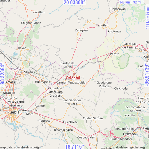
Oriental GPS coordinates[2]
19° 22' 34.104" North, 97° 37' 13.836" West
| Map corner | latitude | longitude |
|---|---|---|
| Upper-left | 20.03808°, | -98.32364° |
| Center: | 19.37614°, | -97.62051° |
| Lower-right: | 18.7115°, | -96.91739° |
| Map W x H: | 147.5×147.5 km | = 91.7×91.7mi |
| max Lat: | 32.7° ⇑56.9% North |
| Oriental: | 19.37614° |
| min Lat: | ⇓43.1% South 14.53588° |
| min Long | Oriental | max Long |
| -117.105° | -97.62051° | -86.73105° |
| W 68.2%⇐ | ⇒31.8% E |
Elevation
Elevation of Oriental is 2354 m = 7723 ft, and this is 1100.3 m = 3610 ft above average elevation for this country.
| Max E: |
3497 m = 11473 ft | 11.6% |
| Oriental | 2354 m 7723 ft | |
| Avg. | 1253.7 m = 4113 ft | |
Min E: |
-1 m = -3 ft | 88.4% |
See also: Mexico elevation on elevation.city.
Geographical zone
Oriental is located in North Torrid zone (between Equator and Tropic of Cancer). Distance of this Northern Tropic circle is 451.5 km =280.5 mi to North.| Distance of | km | miles | from Oriental |
|---|---|---|---|
| North Pole | 7852.6 | 4879.4 | to North |
| Arctic Circle | 5246.7 | 3260.1 | to North |
| Tropic Cancer | 451.5 | 280.5 | to North |
| Equator | 2154.4 | 1338.7 | to South |


Nearby cities:
15 places around Oriental: (largest is in red/bold)
• Ayehualaco (San Martín)
11.4 km =7.1 mi,  307°
307°
• Colonia José María Morelos
8.3 km =5.2 mi,  258°
258°
• El Fuerte de la Unión
8.7 km =5.4 mi,  45°
45°
• Guerrero
9.4 km =5.8 mi, 311°
• La Soledad
7.6 km =4.7 mi, 255°
• Miravalles
9.4 km =5.8 mi,  114°
114°
• Nuevo Centro de Población Tlachichuca
11.7 km =7.3 mi,  152°
152°
• Nuevo México
8.8 km =5.5 mi,  2°
2°
• Nuevo Vicencio
12 km =7.5 mi,  214°
214°
• San Antonio Virreyes
4.1 km =2.5 mi,  335°
335°
• San Carlos
10.1 km =6.3 mi, 313°
• San Francisco Cuexcontzi
11.3 km =7 mi,  236°
236°
• Santa Cruz Magdalena
3 km =1.9 mi, 256°
• Villa de El Carmen Tequexquitla
6.7 km =4.2 mi, 210°
• Álvaro Obregón (San Francisco)
9.7 km =6 mi,  321°
321°
Sources, notices
• [Note1] Compared only with cities in Mexico existing in our database
• [Src1] Map data: © OpenStreetMap contributors (CC-BY-SA)
• [Src2] Other city data from geonames.org with taken over terms of usage.
• [Src3] Geographical zone / Annual Mean Temperature by Robert A. Rohde @ Wikipedia
