Guerrero geodata
Guerrero (Puebla) is a populated place; located in Mexico in America/Mexico_City (GMT-6) time zone. With population of 713 people, there are 12219 cities with bigger population in this country. Compared to other cities in Mexico, 55.5% of cities are located further ↑North; 67.4% of cities are located further ←West and 90% of cities have lower elevation than Guerrero. Note1


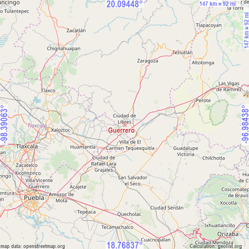
Guerrero GPS coordinates[2]
19° 25' 58.008" North, 97° 41' 15" West
| Map corner | latitude | longitude |
|---|---|---|
| Upper-left | 20.09448°, | -98.39063° |
| Center: | 19.43278°, | -97.6875° |
| Lower-right: | 18.76837°, | -96.98438° |
| Map W x H: | 147.4×147.5 km | = 91.6×91.7mi |
| max Lat: | 32.7° ⇑55.5% North |
| Guerrero: | 19.43278° |
| min Lat: | ⇓44.5% South 14.53588° |
| min Long | Guerrero | max Long |
| -117.105° | -97.6875° | -86.73105° |
| W 67.4%⇐ | ⇒32.6% E |
Elevation
Elevation of Guerrero is 2408 m = 7900 ft, and this is 1154.3 m = 3787 ft above average elevation for this country.
| Max E: |
3497 m = 11473 ft | 10% |
| Guerrero | 2408 m 7900 ft | |
| Avg. | 1253.7 m = 4113 ft | |
Min E: |
-1 m = -3 ft | 90% |
See also: Mexico elevation on elevation.city.
Geographical zone
Guerrero is located in North Torrid zone (between Equator and Tropic of Cancer). Distance of this Northern Tropic circle is 445.2 km =276.6 mi to North.| Distance of | km | miles | from Guerrero |
|---|---|---|---|
| North Pole | 7846.3 | 4875.5 | to North |
| Arctic Circle | 5240.5 | 3256.3 | to North |
| Tropic Cancer | 445.2 | 276.6 | to North |
| Equator | 2160.7 | 1342.6 | to South |


Nearby cities:
15 places around Guerrero: (largest is in red/bold)
• Ayehualaco (San Martín)
2.1 km =1.3 mi,  287°
287°
• Colonia José María Morelos
8 km =5 mi,  188°
188°
• Cuauhtzolco
6 km =3.7 mi,  7°
7°
• La Cañada
8.8 km =5.5 mi,  326°
326°
• La Soledad
8.2 km =5.1 mi,  181°
181°
• Libres
3.7 km =2.3 mi,  0°
0°
• Nuevo México
7.7 km =4.8 mi,  71°
71°
• Progreso
6.3 km =3.9 mi, 9°
• Ranchería de Pocitos
8.7 km =5.4 mi,  240°
240°
• San Antonio Virreyes
5.9 km =3.7 mi,  115°
115°
• San Carlos
0.7 km =0.4 mi,  336°
336°
• San José la Libertad
6 km =3.7 mi,  345°
345°
• Santa Cruz Magdalena
8.1 km =5 mi,  149°
149°
• Santa María las Cuevas
7.5 km =4.7 mi,  226°
226°
• Álvaro Obregón (San Francisco)
1.6 km =1 mi,  36°
36°
Sources, notices
• [Note1] Compared only with cities in Mexico existing in our database
• [Src1] Map data: © OpenStreetMap contributors (CC-BY-SA)
• [Src2] Other city data from geonames.org with taken over terms of usage.
• [Src3] Geographical zone / Annual Mean Temperature by Robert A. Rohde @ Wikipedia
