La Soledad geodata
La Soledad (Tlaxcala) is a populated place; located in Mexico in America/Mexico_City (GMT-6) time zone. With population of 549 people, there are 15509 cities with bigger population in this country. Compared to other cities in Mexico, 57.4% of cities are located further ↑North; 67.4% of cities are located further ←West and 90.2% of cities have lower elevation than La Soledad. Note1


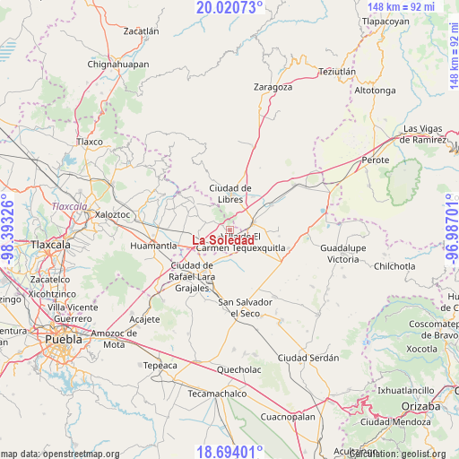
La Soledad GPS coordinates[2]
19° 21' 31.392" North, 97° 41' 24.468" West
| Map corner | latitude | longitude |
|---|---|---|
| Upper-left | 20.02073°, | -98.39326° |
| Center: | 19.35872°, | -97.69013° |
| Lower-right: | 18.69401°, | -96.98701° |
| Map W x H: | 147.5×147.5 km | = 91.7×91.7mi |
| max Lat: | 32.7° ⇑57.4% North |
| La Soledad: | 19.35872° |
| min Lat: | ⇓42.6% South 14.53588° |
| min Long | La Soledad | max Long |
| -117.105° | -97.69013° | -86.73105° |
| W 67.4%⇐ | ⇒32.6% E |
Elevation
Elevation of La Soledad is 2413 m = 7917 ft, and this is 1159.3 m = 3803 ft above average elevation for this country.
| Max E: |
3497 m = 11473 ft | 9.8% |
| La Soledad | 2413 m 7917 ft | |
| Avg. | 1253.7 m = 4113 ft | |
Min E: |
-1 m = -3 ft | 90.2% |
See also: Mexico elevation on elevation.city.
Geographical zone
La Soledad is located in North Torrid zone (between Equator and Tropic of Cancer). Distance of this Northern Tropic circle is 453.4 km =281.7 mi to North.| Distance of | km | miles | from La Soledad |
|---|---|---|---|
| North Pole | 7854.6 | 4880.6 | to North |
| Arctic Circle | 5248.7 | 3261.4 | to North |
| Tropic Cancer | 453.4 | 281.7 | to North |
| Equator | 2152.5 | 1337.5 | to South |


Nearby cities:
15 places around La Soledad: (largest is in red/bold)
• Ayehualaco (San Martín)
9 km =5.6 mi,  348°
348°
• Colonia José María Morelos
0.9 km =0.6 mi,  290°
290°
• Guerrero
8.2 km =5.1 mi,  1°
1°
• Nuevo Vicencio
7.9 km =4.9 mi,  176°
176°
• Oriental
7.6 km =4.7 mi,  75°
75°
• Plan de Ayala
7.5 km =4.7 mi,  222°
222°
• Ranchería de Pocitos
8.3 km =5.2 mi,  298°
298°
• San Antonio Virreyes
8 km =5 mi,  44°
44°
• San Carlos
8.9 km =5.5 mi,  359°
359°
• San Francisco Cuexcontzi
4.8 km =3 mi,  207°
207°
• Santa Cruz Magdalena
4.5 km =2.8 mi,  73°
73°
• Santa Cruz Pocitos
7.8 km =4.8 mi, 287°
• Santa María las Cuevas
6 km =3.7 mi, 300°
• Villa de El Carmen Tequexquitla
5.4 km =3.4 mi,  134°
134°
• Álvaro Obregón (San Francisco)
9.6 km =6 mi,  7°
7°
Sources, notices
• [Note1] Compared only with cities in Mexico existing in our database
• [Src1] Map data: © OpenStreetMap contributors (CC-BY-SA)
• [Src2] Other city data from geonames.org with taken over terms of usage.
• [Src3] Geographical zone / Annual Mean Temperature by Robert A. Rohde @ Wikipedia
