Nuevo Laredo geodata
Nuevo Laredo (Tamaulipas) is a populated place; located in Mexico in America/Matamoros (GMT-5) time zone. With population of 373,725 people, there are 53 cities with bigger population in this country. Compared to other cities in Mexico, 96.9% of cities are located further ↓South; 57.1% of cities are located further →East and 78.1% of cities have higher elevation than Nuevo Laredo. Note1


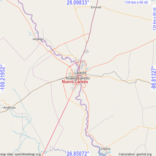
Nuevo Laredo GPS coordinates[2]
27° 28' 34.644" North, 99° 30' 59.004" West
| Map corner | latitude | longitude |
|---|---|---|
| Upper-left | 28.09833°, | -100.21952° |
| Center: | 27.47629°, | -99.51639° |
| Lower-right: | 26.85072°, | -98.81327° |
| Map W x H: | 138.7×138.7 km | = 86.2×86.2mi |
| max Lat: | 32.7° ⇑3.1% North |
| Nuevo Laredo: | 27.47629° |
| min Lat: | ⇓96.9% South 14.53588° |
| min Long | Nuevo Laredo | max Long |
| -117.105° | -99.51639° | -86.73105° |
| W 42.9%⇐ | ⇒57.1% E |
Elevation
Elevation of Nuevo Laredo is 130 m = 427 ft, and this is 1123.7 m = 3687 ft below average elevation for this country.
| Max E: |
3497 m = 11473 ft | 78.1% |
| Avg. | 1253.7 m = 4113 ft | |
| Nuevo Laredo | 130 m = 427 ft | |
Min E: |
-1 m = -3 ft | 21.9% |
See also: Nuevo Laredo elevation on elevation.city.
Geographical zone
Nuevo Laredo is located in North temperate zone (between Tropic of Cancer and the Arctic Circle). Distance of this Northern Tropic circle is 449.2 km =279.1 mi to South.| Distance of | km | miles | from Nuevo Laredo |
|---|---|---|---|
| North Pole | 6952 | 4319.8 | to North |
| Arctic Circle | 4346.1 | 2700.5 | to North |
| Tropic Cancer | 449.2 | 279.1 | to South |
| Equator | 3055.1 | 1898.4 | to South |


Nearby cities:
15 places around Nuevo Laredo: (largest is in red/bold)
• Agualeguas
129.3 km =80.3 mi,  180°
180°
• Anáhuac
66.1 km =41.1 mi,  247°
247°
• Ciudad Miguel Alemán
129.1 km =80.2 mi,  157°
157°
• Ciudad Sabinas Hidalgo
126.7 km =78.7 mi,  211°
211°
• Colombia
34.7 km =21.6 mi,  316°
316°
• El Campanario y Oradel
10.2 km =6.3 mi,  267°
267°
• Guerrero
125.7 km =78.1 mi, 317°
• Hidalgo
49.8 km =30.9 mi,  314°
314°
• Juárez
120.2 km =74.7 mi,  276°
276°
• Lampazos de Naranjo
109.9 km =68.3 mi,  242°
242°
• Los Guerra
127.9 km =79.5 mi, 160°
• Mier
121.8 km =75.7 mi, 162°
• Nueva Ciudad Guerrero
105.6 km =65.6 mi, 164°
• Parás
108.5 km =67.4 mi, 180°
• Vallecillo
102 km =63.4 mi, 207°
Sources, notices
• [Note1] Compared only with cities in Mexico existing in our database
• [Src1] Map data: © OpenStreetMap contributors (CC-BY-SA)
• [Src2] Other city data from geonames.org with taken over terms of usage.
• [Src3] Geographical zone / Annual Mean Temperature by Robert A. Rohde @ Wikipedia
