Anáhuac geodata
Anáhuac (Nuevo León) is a seat of a second-order administrative division; located in Mexico in America/Matamoros (GMT-5) time zone. With population of 16,628 people, there are 576 cities with bigger population in this country. Compared to other cities in Mexico, 96.6% of cities are located further ↓South; 65.6% of cities are located further →East and 75.8% of cities have higher elevation than Anáhuac. Note1


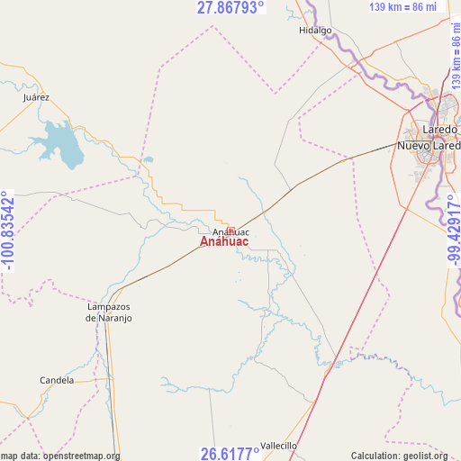
Anáhuac GPS coordinates[2]
27° 14' 40.452" North, 100° 7' 56.244" West
| Map corner | latitude | longitude |
|---|---|---|
| Upper-left | 27.86793°, | -100.83542° |
| Center: | 27.24457°, | -100.13229° |
| Lower-right: | 26.6177°, | -99.42917° |
| Map W x H: | 139×139 km | = 86.4×86.4mi |
| max Lat: | 32.7° ⇑3.4% North |
| Anáhuac: | 27.24457° |
| min Lat: | ⇓96.6% South 14.53588° |
| min Long | Anáhuac | max Long |
| -117.105° | -100.13229° | -86.73105° |
| W 34.4%⇐ | ⇒65.6% E |
Elevation
Elevation of Anáhuac is 197 m = 646 ft, and this is 1056.7 m = 3467 ft below average elevation for this country.
| Max E: |
3497 m = 11473 ft | 75.8% |
| Avg. | 1253.7 m = 4113 ft | |
| Anáhuac | 197 m = 646 ft | |
Min E: |
-1 m = -3 ft | 24.2% |
See also: Mexico elevation on elevation.city.
Geographical zone
Anáhuac is located in North temperate zone (between Tropic of Cancer and the Arctic Circle). Distance of this Northern Tropic circle is 423.4 km =263.1 mi to South.| Distance of | km | miles | from Anáhuac |
|---|---|---|---|
| North Pole | 6977.7 | 4335.7 | to North |
| Arctic Circle | 4371.9 | 2716.6 | to North |
| Tropic Cancer | 423.4 | 263.1 | to South |
| Equator | 3029.3 | 1882.3 | to South |


Nearby cities:
15 places around Anáhuac: (largest is in red/bold)
• Bustamante
87.2 km =54.2 mi,  205°
205°
• Candela
69.5 km =43.2 mi,  229°
229°
• Ciudad Sabinas Hidalgo
82.5 km =51.3 mi,  183°
183°
• Ciudad de Villaldama
87.8 km =54.6 mi,  199°
199°
• Colombia
62.9 km =39.1 mi,  35°
35°
• El Campanario y Oradel
56.6 km =35.2 mi,  63°
63°
• El Potrero
98.2 km =61 mi, 197°
• Hidalgo
65.7 km =40.8 mi,  22°
22°
• Juárez
71.2 km =44.2 mi,  304°
304°
• Lampazos de Naranjo
44.2 km =27.5 mi,  236°
236°
• Nuevo Laredo
66.1 km =41.1 mi,  67°
67°
• Parás
102.6 km =63.8 mi,  143°
143°
• Primero de Mayo
107.9 km =67 mi,  269°
269°
• Progreso
87 km =54.1 mi,  283°
283°
• Vallecillo
66.5 km =41.3 mi,  167°
167°
Sources, notices
• [Note1] Compared only with cities in Mexico existing in our database
• [Src1] Map data: © OpenStreetMap contributors (CC-BY-SA)
• [Src2] Other city data from geonames.org with taken over terms of usage.
• [Src3] Geographical zone / Annual Mean Temperature by Robert A. Rohde @ Wikipedia
