Hidalgo geodata
Hidalgo (Coahuila) is a seat of a second-order administrative division; located in Mexico in America/Monterrey (GMT-6) time zone. With population of 1,638 people, there are 5289 cities with bigger population in this country. Compared to other cities in Mexico, 97.1% of cities are located further ↓South; 62.4% of cities are located further →East and 76.9% of cities have higher elevation than Hidalgo. Note1


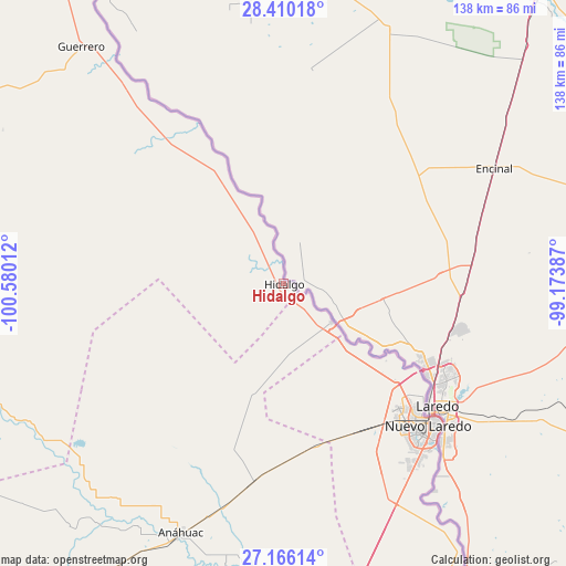
Hidalgo GPS coordinates[2]
27° 47' 23.784" North, 99° 52' 37.164" West
| Map corner | latitude | longitude |
|---|---|---|
| Upper-left | 28.41018°, | -100.58012° |
| Center: | 27.78994°, | -99.87699° |
| Lower-right: | 27.16614°, | -99.17387° |
| Map W x H: | 138.3×138.3 km | = 85.9×85.9mi |
| max Lat: | 32.7° ⇑2.9% North |
| Hidalgo: | 27.78994° |
| min Lat: | ⇓97.1% South 14.53588° |
| min Long | Hidalgo | max Long |
| -117.105° | -99.87699° | -86.73105° |
| W 37.6%⇐ | ⇒62.4% E |
Elevation
Elevation of Hidalgo is 156 m = 512 ft, and this is 1097.7 m = 3601 ft below average elevation for this country.
| Max E: |
3497 m = 11473 ft | 76.9% |
| Avg. | 1253.7 m = 4113 ft | |
| Hidalgo | 156 m = 512 ft | |
Min E: |
-1 m = -3 ft | 23.1% |
See also: Mexico elevation on elevation.city.
Geographical zone
Hidalgo is located in North temperate zone (between Tropic of Cancer and the Arctic Circle). Distance of this Northern Tropic circle is 484 km =300.7 mi to South.| Distance of | km | miles | from Hidalgo |
|---|---|---|---|
| North Pole | 6917.1 | 4298.1 | to North |
| Arctic Circle | 4311.2 | 2678.9 | to North |
| Tropic Cancer | 484 | 300.7 | to South |
| Equator | 3090 | 1920 | to South |


Nearby cities:
15 places around Hidalgo: (largest is in red/bold)
• Allende
113.5 km =70.5 mi,  302°
302°
• Anáhuac
65.7 km =40.8 mi,  202°
202°
• Colombia
15.1 km =9.4 mi,  129°
129°
• Colonia Venustiano Carranza
115.5 km =71.8 mi,  324°
324°
• El Campanario y Oradel
43.4 km =27 mi,  144°
144°
• Guerrero
76.1 km =47.3 mi, 319°
• Juárez
86.1 km =53.5 mi,  256°
256°
• Lampazos de Naranjo
105.2 km =65.4 mi,  216°
216°
• Nava
111.9 km =69.5 mi,  308°
308°
• Nuevo Laredo
49.8 km =30.9 mi, 134°
• Piedras Negras
119.4 km =74.2 mi,  327°
327°
• Progreso
116.7 km =72.5 mi,  249°
249°
• Río Bravo
117.4 km =72.9 mi, 299°
• Villa Union
95.1 km =59.1 mi, 299°
• Villa Unión
96.2 km =59.8 mi, 299°
Sources, notices
• [Note1] Compared only with cities in Mexico existing in our database
• [Src1] Map data: © OpenStreetMap contributors (CC-BY-SA)
• [Src2] Other city data from geonames.org with taken over terms of usage.
• [Src3] Geographical zone / Annual Mean Temperature by Robert A. Rohde @ Wikipedia
