Nogales geodata
Nogales (Veracruz) is a seat of a second-order administrative division; located in Mexico in America/Mexico_City (GMT-6) time zone. With population of 22,085 people, there are 466 cities with bigger population in this country. Compared to other cities in Mexico, 68.3% of cities are located further ↑North; 72.8% of cities are located further ←West and 52.7% of cities have higher elevation than Nogales. Note1


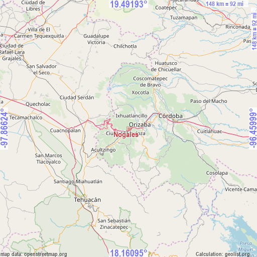
Nogales GPS coordinates[2]
18° 49' 39.936" North, 97° 9' 47.196" West
| Map corner | latitude | longitude |
|---|---|---|
| Upper-left | 19.49193°, | -97.86624° |
| Center: | 18.82776°, | -97.16311° |
| Lower-right: | 18.16095°, | -96.45999° |
| Map W x H: | 148×148 km | = 92×92mi |
| max Lat: | 32.7° ⇑68.3% North |
| Nogales: | 18.82776° |
| min Lat: | ⇓31.7% South 14.53588° |
| min Long | Nogales | max Long |
| -117.105° | -97.16311° | -86.73105° |
| W 72.8%⇐ | ⇒27.2% E |
Elevation
Elevation of Nogales is 1308 m = 4291 ft, and this is 54.3 m = 178 ft above average elevation for this country.
| Max E: |
3497 m = 11473 ft | 52.7% |
| Nogales | 1308 m 4291 ft | |
| Avg. | 1253.7 m = 4113 ft | |
Min E: |
-1 m = -3 ft | 47.3% |
See also: Mexico elevation on elevation.city.
Geographical zone
Nogales is located in North Torrid zone (between Equator and Tropic of Cancer). Distance of this Northern Tropic circle is 512.5 km =318.5 mi to North.| Distance of | km | miles | from Nogales |
|---|---|---|---|
| North Pole | 7913.6 | 4917.3 | to North |
| Arctic Circle | 5307.7 | 3298.1 | to North |
| Tropic Cancer | 512.5 | 318.5 | to North |
| Equator | 2093.5 | 1300.8 | to South |


Nearby cities:
15 places around Nogales: (largest is in red/bold)
• Agrícola Lázaro Cárdenas
4 km =2.5 mi,  247°
247°
• Barrio de Tetzmola
6.5 km =4 mi,  170°
170°
• Campesina el Mirador
4.7 km =2.9 mi,  237°
237°
• Ciudad Mendoza
2.9 km =1.8 mi,  214°
214°
• Donato Guerra
6 km =3.7 mi,  89°
89°
• Fraccionamiento Valle Dorado
6.3 km =3.9 mi,  43°
43°
• Huiloapan de Cuauhtémoc
1.5 km =0.9 mi,  142°
142°
• La Cuesta
4.2 km =2.6 mi,  187°
187°
• Necoxtla
5.6 km =3.5 mi, 169°
• Paredón Viejo
3 km =1.9 mi,  74°
74°
• Paseo Nuevo
5.4 km =3.4 mi,  224°
224°
• Rancho de Pala
6.7 km =4.2 mi,  23°
23°
• Río Blanco
0.8 km =0.5 mi, 68°
• San Cristóbal
4.1 km =2.5 mi, 86°
• Taza de Agua Ojo Zarco
6.4 km =4 mi, 219°
Sources, notices
• [Note1] Compared only with cities in Mexico existing in our database
• [Src1] Map data: © OpenStreetMap contributors (CC-BY-SA)
• [Src2] Other city data from geonames.org with taken over terms of usage.
• [Src3] Geographical zone / Annual Mean Temperature by Robert A. Rohde @ Wikipedia
