La Cuesta geodata
La Cuesta (Veracruz) is a populated place; located in Mexico in America/Mexico_City (GMT-6) time zone. With population of 2,095 people, there are 4163 cities with bigger population in this country. Compared to other cities in Mexico, 68.8% of cities are located further ↑North; 72.8% of cities are located further ←West and 57.2% of cities have lower elevation than La Cuesta. Note1


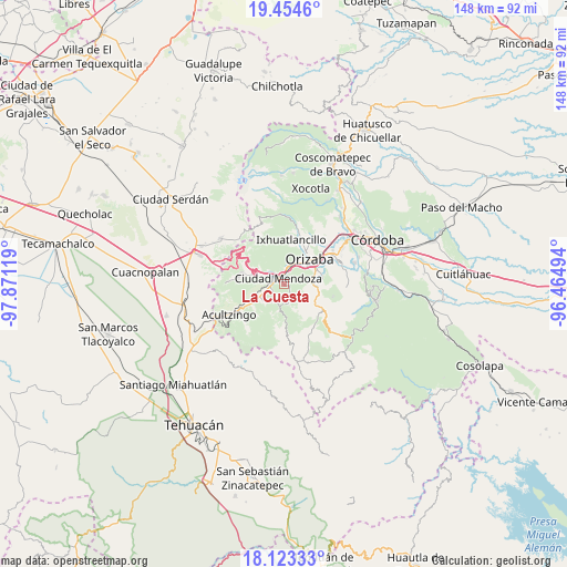
La Cuesta GPS coordinates[2]
18° 47' 25.008" North, 97° 10' 5.016" West
| Map corner | latitude | longitude |
|---|---|---|
| Upper-left | 19.4546°, | -97.87119° |
| Center: | 18.79028°, | -97.16806° |
| Lower-right: | 18.12333°, | -96.46494° |
| Map W x H: | 148×148 km | = 92×92mi |
| max Lat: | 32.7° ⇑68.8% North |
| La Cuesta: | 18.79028° |
| min Lat: | ⇓31.2% South 14.53588° |
| min Long | La Cuesta | max Long |
| -117.105° | -97.16806° | -86.73105° |
| W 72.8%⇐ | ⇒27.2% E |
Elevation
Elevation of La Cuesta is 1666 m = 5466 ft, and this is 412.3 m = 1353 ft above average elevation for this country.
| Max E: |
3497 m = 11473 ft | 42.8% |
| La Cuesta | 1666 m 5466 ft | |
| Avg. | 1253.7 m = 4113 ft | |
Min E: |
-1 m = -3 ft | 57.2% |
See also: Mexico elevation on elevation.city.
Geographical zone
La Cuesta is located in North Torrid zone (between Equator and Tropic of Cancer). Distance of this Northern Tropic circle is 516.6 km =321 mi to North.| Distance of | km | miles | from La Cuesta |
|---|---|---|---|
| North Pole | 7917.8 | 4919.9 | to North |
| Arctic Circle | 5311.9 | 3300.7 | to North |
| Tropic Cancer | 516.6 | 321 | to North |
| Equator | 2089.3 | 1298.2 | to South |


Nearby cities:
15 places around La Cuesta: (largest is in red/bold)
• Agrícola Lázaro Cárdenas
4.1 km =2.5 mi,  309°
309°
• Barrio de Tetzmola
2.8 km =1.7 mi,  144°
144°
• Campesina el Mirador
3.8 km =2.4 mi,  296°
296°
• Ciudad Mendoza
2.1 km =1.3 mi,  328°
328°
• El Campanario
3.4 km =2.1 mi,  232°
232°
• Huiloapan de Cuauhtémoc
3.3 km =2.1 mi,  25°
25°
• Huixtitla
5.1 km =3.2 mi,  211°
211°
• Necoxtla
2 km =1.2 mi,  130°
130°
• Nogales
4.2 km =2.6 mi,  7°
7°
• Paseo Nuevo
3.3 km =2.1 mi,  275°
275°
• Rancho Viejo
4.3 km =2.7 mi,  261°
261°
• Río Blanco
4.6 km =2.9 mi,  15°
15°
• Soledad Atzompa
4.3 km =2.7 mi,  154°
154°
• Taza de Agua Ojo Zarco
3.7 km =2.3 mi, 257°
• Tzoncolco
4.7 km =2.9 mi,  111°
111°
Sources, notices
• [Note1] Compared only with cities in Mexico existing in our database
• [Src1] Map data: © OpenStreetMap contributors (CC-BY-SA)
• [Src2] Other city data from geonames.org with taken over terms of usage.
• [Src3] Geographical zone / Annual Mean Temperature by Robert A. Rohde @ Wikipedia
