Huiloapan de Cuauhtémoc geodata
Huiloapan de Cuauhtémoc (Veracruz) is a populated place; located in Mexico in America/Mexico_City (GMT-6) time zone. With population of 4,125 people, there are 2218 cities with bigger population in this country. Compared to other cities in Mexico, 68.4% of cities are located further ↑North; 72.9% of cities are located further ←West and 53% of cities have higher elevation than Huiloapan de Cuauhtémoc. Note1
Current local time in Huiloapan de Cuauhtémoc:
12:35 PM, MondayDifference from your time zone: hours


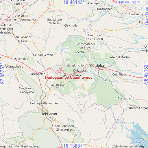
Huiloapan de Cuauhtémoc GPS coordinates[2]
18° 49' 1.992" North, 97° 9' 15.984" West
| Map corner | latitude | longitude |
|---|---|---|
| Upper-left | 19.48143°, | -97.85757° |
| Center: | 18.81722°, | -97.15444° |
| Lower-right: | 18.15037°, | -96.45132° |
| Map W x H: | 148×148 km | = 92×92mi |
| max Lat: | 32.7° ⇑68.4% North |
| Huiloapan de Cuauhtémoc: | 18.81722° |
| min Lat: | ⇓31.6% South 14.53588° |
| min Long | Huiloapan de Cu | max Long |
| -117.105° | -97.15444° | -86.73105° |
| W 72.9%⇐ | ⇒27.1% E |
Elevation
Elevation of Huiloapan de Cuauhtémoc is 1289 m = 4229 ft, and this is 35.3 m = 116 ft above average elevation for this country.
| Max E: |
3497 m = 11473 ft | 53% |
| Huiloapan de Cuauhtémoc | 1289 m 4229 ft | |
| Avg. | 1253.7 m = 4113 ft | |
Min E: |
-1 m = -3 ft | 47% |
See also: Mexico elevation on elevation.city.
Geographical zone
Huiloapan de Cuauhtémoc is located in North Torrid zone (between Equator and Tropic of Cancer). Distance of this Northern Tropic circle is 513.6 km =319.1 mi to North.| Distance of | km | miles | from Huiloapan de Cuauhtémoc |
|---|---|---|---|
| North Pole | 7914.8 | 4918 | to North |
| Arctic Circle | 5308.9 | 3298.8 | to North |
| Tropic Cancer | 513.6 | 319.1 | to North |
| Equator | 2092.3 | 1300.1 | to South |


Nearby cities:
15 places around Huiloapan de Cuauhtémoc: (largest is in red/bold)
• Agrícola Lázaro Cárdenas
4.6 km =2.9 mi,  265°
265°
• Barrio de Tetzmola
5.3 km =3.3 mi,  178°
178°
• Campesina el Mirador
5 km =3.1 mi,  255°
255°
• Ciudad Mendoza
2.8 km =1.7 mi,  244°
244°
• Donato Guerra
5.3 km =3.3 mi,  76°
76°
• La Cuesta
3.3 km =2.1 mi,  205°
205°
• Necoxtla
4.3 km =2.7 mi, 178°
• Nogales
1.5 km =0.9 mi,  322°
322°
• Paredón Viejo
2.8 km =1.7 mi,  45°
45°
• Paseo Nuevo
5.4 km =3.4 mi, 240°
• Río Blanco
1.5 km =0.9 mi,  353°
353°
• San Cristóbal
3.5 km =2.2 mi,  66°
66°
• Taza de Agua Ojo Zarco
6.3 km =3.9 mi,  233°
233°
• Tlilapan
6 km =3.7 mi,  102°
102°
• Tzoncolco
5.6 km =3.5 mi,  148°
148°
Sources, notices
• [Note1] Compared only with cities in Mexico existing in our database
• [Src1] Map data: © OpenStreetMap contributors (CC-BY-SA)
• [Src2] Other city data from geonames.org with taken over terms of usage.
• [Src3] Geographical zone / Annual Mean Temperature by Robert A. Rohde @ Wikipedia
