Paredón Viejo geodata
Paredón Viejo (Veracruz) is a populated place; located in Mexico in America/Mexico_City (GMT-6) time zone. With population of 508 people, there are 16554 cities with bigger population in this country. Compared to other cities in Mexico, 68.1% of cities are located further ↑North; 73.2% of cities are located further ←West and 53.6% of cities have higher elevation than Paredón Viejo. Note1


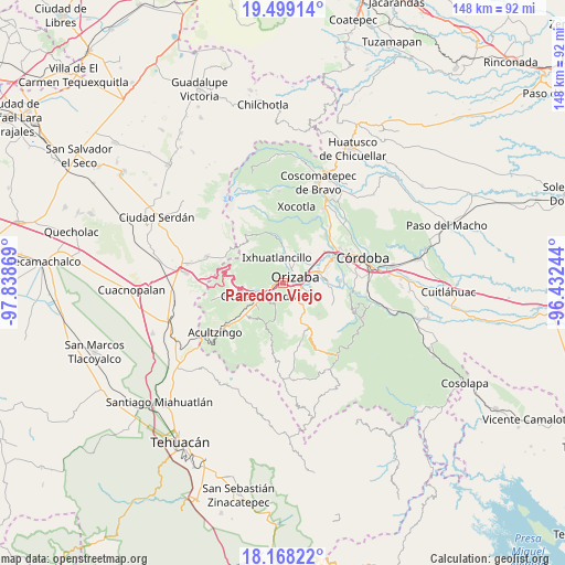
Paredón Viejo GPS coordinates[2]
18° 50' 6" North, 97° 8' 8.016" West
| Map corner | latitude | longitude |
|---|---|---|
| Upper-left | 19.49914°, | -97.83869° |
| Center: | 18.835°, | -97.13556° |
| Lower-right: | 18.16822°, | -96.43244° |
| Map W x H: | 148×148 km | = 92×92mi |
| max Lat: | 32.7° ⇑68.1% North |
| Paredón Viejo: | 18.835° |
| min Lat: | ⇓31.9% South 14.53588° |
| min Long | Paredón Viejo | max Long |
| -117.105° | -97.13556° | -86.73105° |
| W 73.2%⇐ | ⇒26.8% E |
Elevation
Elevation of Paredón Viejo is 1263 m = 4144 ft, and this is 9.3 m = 31 ft above average elevation for this country.
| Max E: |
3497 m = 11473 ft | 53.6% |
| Paredón Viejo | 1263 m 4144 ft | |
| Avg. | 1253.7 m = 4113 ft | |
Min E: |
-1 m = -3 ft | 46.4% |
See also: Mexico elevation on elevation.city.
Geographical zone
Paredón Viejo is located in North Torrid zone (between Equator and Tropic of Cancer). Distance of this Northern Tropic circle is 511.7 km =318 mi to North.| Distance of | km | miles | from Paredón Viejo |
|---|---|---|---|
| North Pole | 7912.8 | 4916.8 | to North |
| Arctic Circle | 5306.9 | 3297.6 | to North |
| Tropic Cancer | 511.7 | 318 | to North |
| Equator | 2094.3 | 1301.3 | to South |


Nearby cities:
15 places around Paredón Viejo: (largest is in red/bold)
• Ciudad Mendoza
5.5 km =3.4 mi,  235°
235°
• Donato Guerra
3.2 km =2 mi,  103°
103°
• Fraccionamiento Valle Dorado
4 km =2.5 mi,  20°
20°
• Huiloapan de Cuauhtémoc
2.8 km =1.7 mi,  225°
225°
• Jalapilla
5 km =3.1 mi, 100°
• La Cuesta
6 km =3.7 mi,  214°
214°
• Nogales
3 km =1.9 mi,  254°
254°
• Orizaba
4.2 km =2.6 mi,  63°
63°
• Palmira
5.9 km =3.7 mi,  25°
25°
• Rancho de Pala
5.3 km =3.3 mi,  357°
357°
• Río Blanco
2.2 km =1.4 mi,  256°
256°
• San Cristóbal
1.4 km =0.9 mi,  115°
115°
• San Isidro
6.3 km =3.9 mi,  9°
9°
• Tlilapan
5.1 km =3.2 mi,  130°
130°
• Unión y Progreso
4.5 km =2.8 mi, 22°
Sources, notices
• [Note1] Compared only with cities in Mexico existing in our database
• [Src1] Map data: © OpenStreetMap contributors (CC-BY-SA)
• [Src2] Other city data from geonames.org with taken over terms of usage.
• [Src3] Geographical zone / Annual Mean Temperature by Robert A. Rohde @ Wikipedia
