Jalupa geodata
Jalupa (Tabasco) is a populated place; located in Mexico in America/Mexico_City (GMT-6) time zone. With population of 4,800 people, there are 1929 cities with bigger population in this country. Compared to other cities in Mexico, 77.1% of cities are located further ↑North; 88.3% of cities are located further ←West and 96.3% of cities have higher elevation than Jalupa. Note1


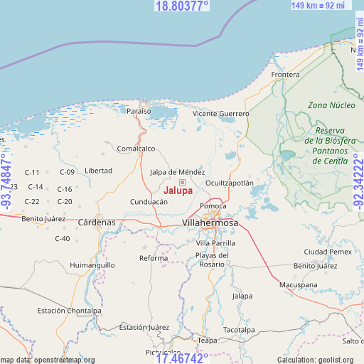
Jalupa GPS coordinates[2]
18° 8' 12.732" North, 93° 2' 43.224" West
| Map corner | latitude | longitude |
|---|---|---|
| Upper-left | 18.80377°, | -93.74847° |
| Center: | 18.13687°, | -93.04534° |
| Lower-right: | 17.46742°, | -92.34222° |
| Map W x H: | 148.6×148.6 km | = 92.3×92.3mi |
| max Lat: | 32.7° ⇑77.1% North |
| Jalupa: | 18.13687° |
| min Lat: | ⇓22.9% South 14.53588° |
| min Long | Jalupa | max Long |
| -117.105° | -93.04534° | -86.73105° |
| W 88.3%⇐ | ⇒11.7% E |
Elevation
Elevation of Jalupa is 11 m = 36 ft, and this is 1242.7 m = 4077 ft below average elevation for this country.
| Max E: |
3497 m = 11473 ft | 96.3% |
| Avg. | 1253.7 m = 4113 ft | |
| Jalupa | 11 m = 36 ft | |
Min E: |
-1 m = -3 ft | 3.7% |
See also: Mexico elevation on elevation.city.
Geographical zone
Jalupa is located in North Torrid zone (between Equator and Tropic of Cancer). Distance of this Northern Tropic circle is 589.3 km =366.2 mi to North.| Distance of | km | miles | from Jalupa |
|---|---|---|---|
| North Pole | 7990.4 | 4965 | to North |
| Arctic Circle | 5384.5 | 3345.8 | to North |
| Tropic Cancer | 589.3 | 366.2 | to North |
| Equator | 2016.6 | 1253.1 | to South |


Nearby cities:
15 places around Jalupa: (largest is in red/bold)
• Corriente 1ra. Sección
5.9 km =3.7 mi,  67°
67°
• Guatacalca
7.7 km =4.8 mi, 65°
• Jalpa de Méndez
4.8 km =3 mi,  336°
336°
• La Cruz
1.6 km =1 mi,  100°
100°
• Mazateupa
8.2 km =5.1 mi,  27°
27°
• Nacajuca
4.6 km =2.9 mi,  37°
37°
• Nicolás Bravo
4.5 km =2.8 mi,  296°
296°
• Pueblo Viejo
8.2 km =5.1 mi,  328°
328°
• Rancho Nuevo
7.8 km =4.8 mi,  201°
201°
• San Hipólito
8.4 km =5.2 mi,  256°
256°
• Santa Lucía
7.5 km =4.7 mi,  242°
242°
• Tapotzingo
8.2 km =5.1 mi,  23°
23°
• Taxco
4.2 km =2.6 mi,  86°
86°
• Tierras Peleadas (Tierras Amigas)
1.4 km =0.9 mi, 41°
• Tucta
8.2 km =5.1 mi, 40°
Sources, notices
• [Note1] Compared only with cities in Mexico existing in our database
• [Src1] Map data: © OpenStreetMap contributors (CC-BY-SA)
• [Src2] Other city data from geonames.org with taken over terms of usage.
• [Src3] Geographical zone / Annual Mean Temperature by Robert A. Rohde @ Wikipedia
