Río Guerrero geodata
Río Guerrero (Chiapas) is a populated place; located in Mexico in America/Mexico_City (GMT-6) time zone. With population of 939 people, there are 9278 cities with bigger population in this country. Compared to other cities in Mexico, 98.4% of cities are located further ↑North; 94.5% of cities are located further ←West and 64.8% of cities have higher elevation than Río Guerrero. Note1


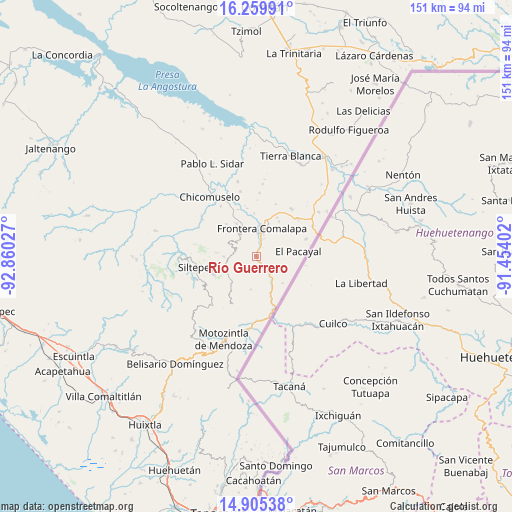
Río Guerrero GPS coordinates[2]
15° 35' 1.536" North, 92° 9' 25.704" West
| Map corner | latitude | longitude |
|---|---|---|
| Upper-left | 16.25991°, | -92.86027° |
| Center: | 15.58376°, | -92.15714° |
| Lower-right: | 14.90538°, | -91.45402° |
| Map W x H: | 150.6×150.6 km | = 93.6×93.6mi |
| max Lat: | 32.7° ⇑98.4% North |
| Río Guerrero: | 15.58376° |
| min Lat: | ⇓1.6% South 14.53588° |
| min Long | Río Guerrero | max Long |
| -117.105° | -92.15714° | -86.73105° |
| W 94.5%⇐ | ⇒5.5% E |
Elevation
Elevation of Río Guerrero is 697 m = 2287 ft, and this is 556.7 m = 1826 ft below average elevation for this country.
| Max E: |
3497 m = 11473 ft | 64.8% |
| Avg. | 1253.7 m = 4113 ft | |
| Río Guerrero | 697 m = 2287 ft | |
Min E: |
-1 m = -3 ft | 35.2% |
See also: Mexico elevation on elevation.city.
Geographical zone
Río Guerrero is located in North Torrid zone (between Equator and Tropic of Cancer). Distance of this Northern Tropic circle is 873.2 km =542.6 mi to North.| Distance of | km | miles | from Río Guerrero |
|---|---|---|---|
| North Pole | 8274.3 | 5141.4 | to North |
| Arctic Circle | 5668.4 | 3522.2 | to North |
| Tropic Cancer | 873.2 | 542.6 | to North |
| Equator | 1732.8 | 1076.7 | to South |


Nearby cities:
15 places around Río Guerrero: (largest is in red/bold)
• Agua Zarca
5.8 km =3.6 mi,  13°
13°
• Bella Vista
9.6 km =6 mi,  269°
269°
• Bellavista del Norte
9.2 km =5.7 mi,  359°
359°
• Comalapa
8.5 km =5.3 mi, 10°
• El Progreso
6.4 km =4 mi, 273°
• El Triunfo de las Tres Maravillas
7 km =4.3 mi,  0°
0°
• La Lima
9.4 km =5.8 mi,  18°
18°
• La Montaña
3.5 km =2.2 mi,  249°
249°
• Monte Ordóñez
2.8 km =1.7 mi,  212°
212°
• Nueva Morelia
4 km =2.5 mi, 18°
• Pacayalito
7 km =4.3 mi,  78°
78°
• Reforma
6.7 km =4.2 mi,  146°
146°
• San José las Chicharras
8.5 km =5.3 mi,  321°
321°
• Unión Progreso
7.7 km =4.8 mi, 272°
• Veinte de Noviembre
8.7 km =5.4 mi,  105°
105°
Sources, notices
• [Note1] Compared only with cities in Mexico existing in our database
• [Src1] Map data: © OpenStreetMap contributors (CC-BY-SA)
• [Src2] Other city data from geonames.org with taken over terms of usage.
• [Src3] Geographical zone / Annual Mean Temperature by Robert A. Rohde @ Wikipedia
