Reforma geodata
Reforma (Chiapas) is a populated place; located in Mexico in America/Mexico_City (GMT-6) time zone. With population of 730 people, there are 11957 cities with bigger population in this country. Compared to other cities in Mexico, 98.5% of cities are located further ↑North; 94.7% of cities are located further ←West and 64.3% of cities have higher elevation than Reforma. Note1


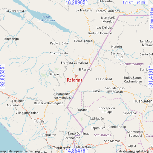
Reforma GPS coordinates[2]
15° 31' 59.988" North, 92° 7' 19.992" West
| Map corner | latitude | longitude |
|---|---|---|
| Upper-left | 16.20965°, | -92.82535° |
| Center: | 15.53333°, | -92.12222° |
| Lower-right: | 14.85479°, | -91.4191° |
| Map W x H: | 150.6×150.6 km | = 93.6×93.6mi |
| max Lat: | 32.7° ⇑98.5% North |
| Reforma: | 15.53333° |
| min Lat: | ⇓1.5% South 14.53588° |
| min Long | Reforma | max Long |
| -117.105° | -92.12222° | -86.73105° |
| W 94.7%⇐ | ⇒5.3% E |
Elevation
Elevation of Reforma is 734 m = 2408 ft, and this is 519.7 m = 1705 ft below average elevation for this country.
| Max E: |
3497 m = 11473 ft | 64.3% |
| Avg. | 1253.7 m = 4113 ft | |
| Reforma | 734 m = 2408 ft | |
Min E: |
-1 m = -3 ft | 35.7% |
See also: Mexico elevation on elevation.city.
Geographical zone
Reforma is located in North Torrid zone (between Equator and Tropic of Cancer). Distance of this Northern Tropic circle is 878.8 km =546.1 mi to North.| Distance of | km | miles | from Reforma |
|---|---|---|---|
| North Pole | 8279.9 | 5144.9 | to North |
| Arctic Circle | 5674 | 3525.7 | to North |
| Tropic Cancer | 878.8 | 546.1 | to North |
| Equator | 1727.1 | 1073.2 | to South |


Nearby cities:
15 places around Reforma: (largest is in red/bold)
• Amatenango de la Frontera
11 km =6.8 mi,  176°
176°
• Bejucal de Ocampo
9.5 km =5.9 mi,  204°
204°
• El Pino
9.8 km =6.1 mi,  207°
207°
• Francisco I. Madero
4.2 km =2.6 mi,  118°
118°
• Guadalupe Victoria
10.3 km =6.4 mi,  38°
38°
• La Montaña
8.3 km =5.2 mi,  301°
301°
• Miguel Hidalgo
3.5 km =2.2 mi,  128°
128°
• Monte Ordóñez
6.2 km =3.9 mi, 301°
• Nueva Morelia
9.7 km =6 mi,  345°
345°
• Nuevo Amatenango
3.1 km =1.9 mi,  153°
153°
• Ojo de Agua Centro
6.8 km =4.2 mi,  233°
233°
• Ojo de Agua Grande
6.5 km =4 mi,  221°
221°
• Pacayalito
7.6 km =4.7 mi,  24°
24°
• Río Guerrero
6.7 km =4.2 mi,  326°
326°
• Veinte de Noviembre
5.7 km =3.5 mi,  55°
55°
Sources, notices
• [Note1] Compared only with cities in Mexico existing in our database
• [Src1] Map data: © OpenStreetMap contributors (CC-BY-SA)
• [Src2] Other city data from geonames.org with taken over terms of usage.
• [Src3] Geographical zone / Annual Mean Temperature by Robert A. Rohde @ Wikipedia
