Montecristo geodata
Montecristo (Chiapas) is a seat of a second-order administrative division; located in Mexico in America/Mexico_City (GMT-6) time zone. With population of 2,546 people, there are 3480 cities with bigger population in this country. Compared to other cities in Mexico, 98.1% of cities are located further ↑North; 91% of cities are located further ←West and 54.3% of cities have higher elevation than Montecristo. Note1


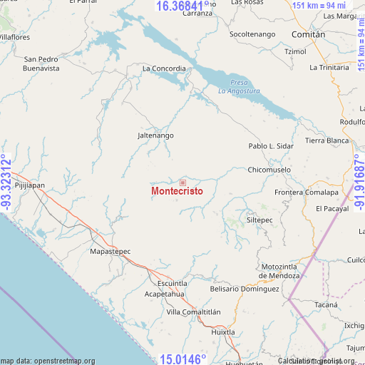
Montecristo GPS coordinates[2]
15° 41' 33.468" North, 92° 37' 11.964" West
| Map corner | latitude | longitude |
|---|---|---|
| Upper-left | 16.36841°, | -93.32312° |
| Center: | 15.69263°, | -92.61999° |
| Lower-right: | 15.0146°, | -91.91687° |
| Map W x H: | 150.5×150.5 km | = 93.5×93.5mi |
| max Lat: | 32.7° ⇑98.1% North |
| Montecristo: | 15.69263° |
| min Lat: | ⇓1.9% South 14.53588° |
| min Long | Montecristo | max Long |
| -117.105° | -92.61999° | -86.73105° |
| W 91%⇐ | ⇒9% E |
Elevation
Elevation of Montecristo is 1227 m = 4026 ft, and this is 26.7 m = 88 ft below average elevation for this country.
| Max E: |
3497 m = 11473 ft | 54.3% |
| Avg. | 1253.7 m = 4113 ft | |
| Montecristo | 1227 m = 4026 ft | |
Min E: |
-1 m = -3 ft | 45.7% |
See also: Mexico elevation on elevation.city.
Geographical zone
Montecristo is located in North Torrid zone (between Equator and Tropic of Cancer). Distance of this Northern Tropic circle is 861.1 km =535.1 mi to North.| Distance of | km | miles | from Montecristo |
|---|---|---|---|
| North Pole | 8262.2 | 5133.9 | to North |
| Arctic Circle | 5656.3 | 3514.7 | to North |
| Tropic Cancer | 861.1 | 535.1 | to North |
| Equator | 1744.9 | 1084.2 | to South |


Nearby cities:
15 places around Montecristo: (largest is in red/bold)
• Buenos Aires
17.6 km =10.9 mi,  132°
132°
• Capitán Luis A. Vidal
10.2 km =6.3 mi,  185°
185°
• Francisco I. Madero
16.3 km =10.1 mi,  334°
334°
• Honduras
19.2 km =11.9 mi, 126°
• La Paz
10 km =6.2 mi,  353°
353°
• Laguna del Cofre
7.6 km =4.7 mi,  197°
197°
• Las Delicias
14.2 km =8.8 mi,  117°
117°
• Libertad del Pajal
10.3 km =6.4 mi,  336°
336°
• Miguel Alemán
14.1 km =8.8 mi,  72°
72°
• Nueva Colombia
10.8 km =6.7 mi,  272°
272°
• Nueva Independencia
5.2 km =3.2 mi,  114°
114°
• Nueva Palestina
18.8 km =11.7 mi,  312°
312°
• Pablo Galeana
15.9 km =9.9 mi,  147°
147°
• San Nicolás Plan de Ayutla
3.3 km =2.1 mi,  25°
25°
• Unión Buenavista
14 km =8.7 mi,  35°
35°
Sources, notices
• [Note1] Compared only with cities in Mexico existing in our database
• [Src1] Map data: © OpenStreetMap contributors (CC-BY-SA)
• [Src2] Other city data from geonames.org with taken over terms of usage.
• [Src3] Geographical zone / Annual Mean Temperature by Robert A. Rohde @ Wikipedia
