Honduras geodata
Honduras (Chiapas) is a populated place; located in Mexico in America/Mexico_City (GMT-6) time zone. With population of 507 people, there are 16589 cities with bigger population in this country. Compared to other cities in Mexico, 98.4% of cities are located further ↑North; 92.1% of cities are located further ←West and 55% of cities have higher elevation than Honduras. Note1


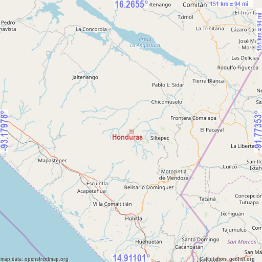
Honduras GPS coordinates[2]
15° 35' 21.732" North, 92° 28' 35.94" West
| Map corner | latitude | longitude |
|---|---|---|
| Upper-left | 16.2655°, | -93.17978° |
| Center: | 15.58937°, | -92.47665° |
| Lower-right: | 14.91101°, | -91.77353° |
| Map W x H: | 150.6×150.6 km | = 93.6×93.6mi |
| max Lat: | 32.7° ⇑98.4% North |
| Honduras: | 15.58937° |
| min Lat: | ⇓1.6% South 14.53588° |
| min Long | Honduras | max Long |
| -117.105° | -92.47665° | -86.73105° |
| W 92.1%⇐ | ⇒7.9% E |
Elevation
Elevation of Honduras is 1199 m = 3934 ft, and this is 54.7 m = 179 ft below average elevation for this country.
| Max E: |
3497 m = 11473 ft | 55% |
| Avg. | 1253.7 m = 4113 ft | |
| Honduras | 1199 m = 3934 ft | |
Min E: |
-1 m = -3 ft | 45% |
See also: Mexico elevation on elevation.city.
Geographical zone
Honduras is located in North Torrid zone (between Equator and Tropic of Cancer). Distance of this Northern Tropic circle is 872.5 km =542.1 mi to North.| Distance of | km | miles | from Honduras |
|---|---|---|---|
| North Pole | 8273.7 | 5141 | to North |
| Arctic Circle | 5667.8 | 3521.8 | to North |
| Tropic Cancer | 872.5 | 542.1 | to North |
| Equator | 1733.4 | 1077.1 | to South |


Nearby cities:
15 places around Honduras: (largest is in red/bold)
• Angel Díaz
9 km =5.6 mi,  119°
119°
• Buenos Aires
2.4 km =1.5 mi,  261°
261°
• Capitán Luis A. Vidal
16.4 km =10.2 mi,  274°
274°
• La Soledad
1.9 km =1.2 mi,  215°
215°
• Las Cruces
16.5 km =10.3 mi,  107°
107°
• Las Delicias
5.7 km =3.5 mi,  330°
330°
• Las Moras
6.1 km =3.8 mi, 123°
• Miguel Alemán
15.7 km =9.8 mi,  353°
353°
• Monte Sinaí
16.2 km =10.1 mi,  46°
46°
• Nueva Independencia
14.1 km =8.8 mi,  311°
311°
• Pablo Galeana
7.1 km =4.4 mi,  253°
253°
• Pinada de Arriba
16.7 km =10.4 mi,  79°
79°
• Santo Domingo (La Cascada)
13.8 km =8.6 mi,  146°
146°
• Siltepec
16.8 km =10.4 mi,  102°
102°
• Toquián Grande
14.7 km =9.1 mi, 116°
Sources, notices
• [Note1] Compared only with cities in Mexico existing in our database
• [Src1] Map data: © OpenStreetMap contributors (CC-BY-SA)
• [Src2] Other city data from geonames.org with taken over terms of usage.
• [Src3] Geographical zone / Annual Mean Temperature by Robert A. Rohde @ Wikipedia
