Laguna del Cofre geodata
Laguna del Cofre (Chiapas) is a populated place; located in Mexico in America/Mexico_City (GMT-6) time zone. With population of 1,055 people, there are 8271 cities with bigger population in this country. Compared to other cities in Mexico, 98.3% of cities are located further ↑North; 90.9% of cities are located further ←West and 64.9% of cities have lower elevation than Laguna del Cofre. Note1


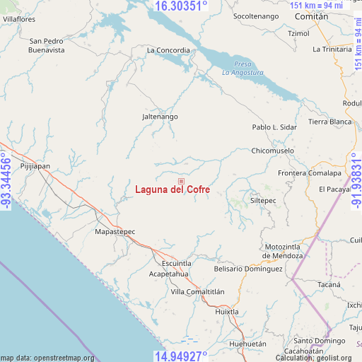
Laguna del Cofre GPS coordinates[2]
15° 37' 39.036" North, 92° 38' 29.148" West
| Map corner | latitude | longitude |
|---|---|---|
| Upper-left | 16.30351°, | -93.34456° |
| Center: | 15.62751°, | -92.64143° |
| Lower-right: | 14.94927°, | -91.93831° |
| Map W x H: | 150.6×150.6 km | = 93.6×93.6mi |
| max Lat: | 32.7° ⇑98.3% North |
| Laguna del Cofre: | 15.62751° |
| min Lat: | ⇓1.7% South 14.53588° |
| min Long | Laguna del Cofr | max Long |
| -117.105° | -92.64143° | -86.73105° |
| W 90.9%⇐ | ⇒9.1% E |
Elevation
Elevation of Laguna del Cofre is 1825 m = 5988 ft, and this is 571.3 m = 1874 ft above average elevation for this country.
| Max E: |
3497 m = 11473 ft | 35.1% |
| Laguna del Cofre | 1825 m 5988 ft | |
| Avg. | 1253.7 m = 4113 ft | |
Min E: |
-1 m = -3 ft | 64.9% |
See also: Mexico elevation on elevation.city.
Geographical zone
Laguna del Cofre is located in North Torrid zone (between Equator and Tropic of Cancer). Distance of this Northern Tropic circle is 868.3 km =539.5 mi to North.| Distance of | km | miles | from Laguna del Cofre |
|---|---|---|---|
| North Pole | 8269.4 | 5138.4 | to North |
| Arctic Circle | 5663.6 | 3519.2 | to North |
| Tropic Cancer | 868.3 | 539.5 | to North |
| Equator | 1737.6 | 1079.7 | to South |


Nearby cities:
15 places around Laguna del Cofre: (largest is in red/bold)
• Buenos Aires
15.9 km =9.9 mi,  106°
106°
• Capitán Luis A. Vidal
3.2 km =2 mi,  155°
155°
• Francisco I. Madero
22.5 km =14 mi,  347°
347°
• Honduras
18.1 km =11.2 mi,  103°
103°
• La Paz
17.2 km =10.7 mi,  3°
3°
• La Soledad
17.5 km =10.9 mi, 109°
• Las Delicias
14.9 km =9.3 mi,  87°
87°
• Libertad del Pajal
16.7 km =10.4 mi, 353°
• Miguel Alemán
19.4 km =12.1 mi,  54°
54°
• Montecristo
7.6 km =4.7 mi,  17°
17°
• Nueva Colombia
11.5 km =7.1 mi,  312°
312°
• Nueva Independencia
8.7 km =5.4 mi, 54°
• Pablo Galeana
12.5 km =7.8 mi,  119°
119°
• San Nicolás Plan de Ayutla
10.9 km =6.8 mi, 20°
• Unión Buenavista
21.4 km =13.3 mi,  29°
29°
Sources, notices
• [Note1] Compared only with cities in Mexico existing in our database
• [Src1] Map data: © OpenStreetMap contributors (CC-BY-SA)
• [Src2] Other city data from geonames.org with taken over terms of usage.
• [Src3] Geographical zone / Annual Mean Temperature by Robert A. Rohde @ Wikipedia
