Matamoros geodata
Matamoros (Campeche) is a populated place; located in Mexico in America/Merida (GMT-6) time zone. With population of 1,453 people, there are 5939 cities with bigger population in this country. Compared to other cities in Mexico, 71.6% of cities are located further ↑North; 97.1% of cities are located further ←West and 79.2% of cities have higher elevation than Matamoros. Note1


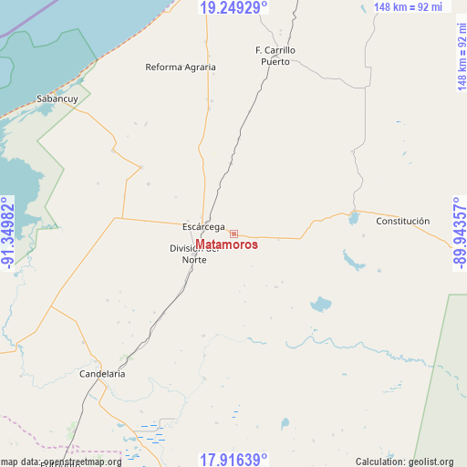
Matamoros GPS coordinates[2]
18° 35' 2.904" North, 90° 38' 48.084" West
| Map corner | latitude | longitude |
|---|---|---|
| Upper-left | 19.24929°, | -91.34982° |
| Center: | 18.58414°, | -90.64669° |
| Lower-right: | 17.91639°, | -89.94357° |
| Map W x H: | 148.2×148.2 km | = 92.1×92.1mi |
| max Lat: | 32.7° ⇑71.6% North |
| Matamoros: | 18.58414° |
| min Lat: | ⇓28.4% South 14.53588° |
| min Long | Matamoros | max Long |
| -117.105° | -90.64669° | -86.73105° |
| W 97.1%⇐ | ⇒2.9% E |
Elevation
Elevation of Matamoros is 108 m = 354 ft, and this is 1145.7 m = 3759 ft below average elevation for this country.
| Max E: |
3497 m = 11473 ft | 79.2% |
| Avg. | 1253.7 m = 4113 ft | |
| Matamoros | 108 m = 354 ft | |
Min E: |
-1 m = -3 ft | 20.8% |
See also: Mexico elevation on elevation.city.
Geographical zone
Matamoros is located in North Torrid zone (between Equator and Tropic of Cancer). Distance of this Northern Tropic circle is 539.6 km =335.3 mi to North.| Distance of | km | miles | from Matamoros |
|---|---|---|---|
| North Pole | 7940.7 | 4934.1 | to North |
| Arctic Circle | 5334.8 | 3314.9 | to North |
| Tropic Cancer | 539.6 | 335.3 | to North |
| Equator | 2066.4 | 1284 | to South |


Nearby cities:
15 places around Matamoros: (largest is in red/bold)
• Abelardo L. Rodríguez
31.5 km =19.6 mi,  300°
300°
• Chicbul
36.2 km =22.5 mi,  306°
306°
• Cinco de Febrero
30.3 km =18.8 mi,  2°
2°
• División del Norte
13.8 km =8.6 mi,  243°
243°
• Don Samuel
33.4 km =20.8 mi,  221°
221°
• El Lechugal
23.5 km =14.6 mi,  85°
85°
• Escárcega
10.8 km =6.7 mi,  284°
284°
• Haro
21.8 km =13.5 mi, 224°
• José de la Cruz Blanco
15.2 km =9.4 mi,  286°
286°
• Justicia Social
27.7 km =17.2 mi,  81°
81°
• La Libertad
14.1 km =8.8 mi,  96°
96°
• La Victoria
31.1 km =19.3 mi,  250°
250°
• Miguel Colorado
22.3 km =13.9 mi,  357°
357°
• Nueva Rosita
33.7 km =20.9 mi,  196°
196°
• Nuevo Progreso Dos
28.6 km =17.8 mi, 278°
Sources, notices
• [Note1] Compared only with cities in Mexico existing in our database
• [Src1] Map data: © OpenStreetMap contributors (CC-BY-SA)
• [Src2] Other city data from geonames.org with taken over terms of usage.
• [Src3] Geographical zone / Annual Mean Temperature by Robert A. Rohde @ Wikipedia
