Nuevo Progreso Dos geodata
Nuevo Progreso Dos (Campeche) is a populated place; located in Mexico in America/Merida (GMT-6) time zone. With population of 664 people, there are 13077 cities with bigger population in this country. Compared to other cities in Mexico, 71.2% of cities are located further ↑North; 96.9% of cities are located further ←West and 87% of cities have higher elevation than Nuevo Progreso Dos. Note1


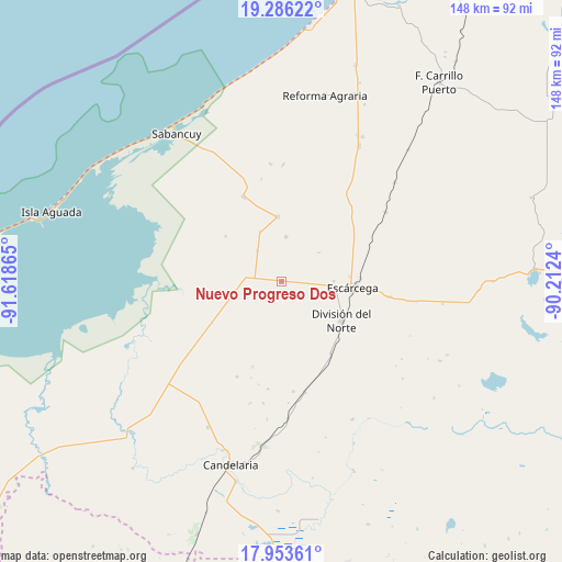
Nuevo Progreso Dos GPS coordinates[2]
18° 37' 16.392" North, 90° 54' 55.872" West
| Map corner | latitude | longitude |
|---|---|---|
| Upper-left | 19.28622°, | -91.61865° |
| Center: | 18.62122°, | -90.91552° |
| Lower-right: | 17.95361°, | -90.2124° |
| Map W x H: | 148.2×148.2 km | = 92.1×92.1mi |
| max Lat: | 32.7° ⇑71.2% North |
| Nuevo Progreso Dos: | 18.62122° |
| min Lat: | ⇓28.8% South 14.53588° |
| min Long | Nuevo Progreso | max Long |
| -117.105° | -90.91552° | -86.73105° |
| W 96.9%⇐ | ⇒3.1% E |
Elevation
Elevation of Nuevo Progreso Dos is 34 m = 112 ft, and this is 1219.7 m = 4002 ft below average elevation for this country.
| Max E: |
3497 m = 11473 ft | 87% |
| Avg. | 1253.7 m = 4113 ft | |
| Nuevo Progreso Dos | 34 m = 112 ft | |
Min E: |
-1 m = -3 ft | 13% |
See also: Mexico elevation on elevation.city.
Geographical zone
Nuevo Progreso Dos is located in North Torrid zone (between Equator and Tropic of Cancer). Distance of this Northern Tropic circle is 535.4 km =332.7 mi to North.| Distance of | km | miles | from Nuevo Progreso Dos |
|---|---|---|---|
| North Pole | 7936.6 | 4931.6 | to North |
| Arctic Circle | 5330.7 | 3312.3 | to North |
| Tropic Cancer | 535.4 | 332.7 | to North |
| Equator | 2070.5 | 1286.5 | to South |


Nearby cities:
15 places around Nuevo Progreso Dos: (largest is in red/bold)
• Abelardo L. Rodríguez
12 km =7.5 mi,  5°
5°
• Chicbul
17.2 km =10.7 mi,  356°
356°
• División del Norte
18.9 km =11.7 mi,  122°
122°
• Escárcega
18 km =11.2 mi,  94°
94°
• Haro
23.6 km =14.7 mi,  146°
146°
• José de la Cruz Blanco
13.8 km =8.6 mi, 89°
• La Cristalina
19 km =11.8 mi,  309°
309°
• La Victoria
14.5 km =9 mi,  183°
183°
• Licenciado Gustavo Díaz Ordaz (18 de Marzo)
9.3 km =5.8 mi,  277°
277°
• Mamantel
21.2 km =13.2 mi,  239°
239°
• Nueva Chontalpa
24.6 km =15.3 mi,  229°
229°
• Oxcabal
27.6 km =17.1 mi,  348°
348°
• Pital Nuevo
12.6 km =7.8 mi,  258°
258°
• Plan de Ayala
17.4 km =10.8 mi, 355°
• San Isidro
14.3 km =8.9 mi, 275°
Sources, notices
• [Note1] Compared only with cities in Mexico existing in our database
• [Src1] Map data: © OpenStreetMap contributors (CC-BY-SA)
• [Src2] Other city data from geonames.org with taken over terms of usage.
• [Src3] Geographical zone / Annual Mean Temperature by Robert A. Rohde @ Wikipedia
