La Victoria geodata
La Victoria (Campeche) is a populated place; located in Mexico in America/Merida (GMT-6) time zone. With population of 878 people, there are 9946 cities with bigger population in this country. Compared to other cities in Mexico, 72.7% of cities are located further ↑North; 96.9% of cities are located further ←West and 84.1% of cities have higher elevation than La Victoria. Note1


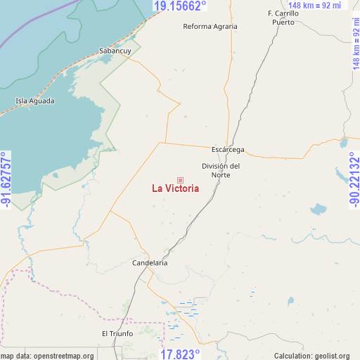
La Victoria GPS coordinates[2]
18° 29' 27.996" North, 90° 55' 27.984" West
| Map corner | latitude | longitude |
|---|---|---|
| Upper-left | 19.15662°, | -91.62757° |
| Center: | 18.49111°, | -90.92444° |
| Lower-right: | 17.823°, | -90.22132° |
| Map W x H: | 148.3×148.3 km | = 92.1×92.1mi |
| max Lat: | 32.7° ⇑72.7% North |
| La Victoria: | 18.49111° |
| min Lat: | ⇓27.3% South 14.53588° |
| min Long | La Victoria | max Long |
| -117.105° | -90.92444° | -86.73105° |
| W 96.9%⇐ | ⇒3.1% E |
Elevation
Elevation of La Victoria is 51 m = 167 ft, and this is 1202.7 m = 3946 ft below average elevation for this country.
| Max E: |
3497 m = 11473 ft | 84.1% |
| Avg. | 1253.7 m = 4113 ft | |
| La Victoria | 51 m = 167 ft | |
Min E: |
-1 m = -3 ft | 15.9% |
See also: Mexico elevation on elevation.city.
Geographical zone
La Victoria is located in North Torrid zone (between Equator and Tropic of Cancer). Distance of this Northern Tropic circle is 549.9 km =341.7 mi to North.| Distance of | km | miles | from La Victoria |
|---|---|---|---|
| North Pole | 7951 | 4940.5 | to North |
| Arctic Circle | 5345.2 | 3321.4 | to North |
| Tropic Cancer | 549.9 | 341.7 | to North |
| Equator | 2056 | 1277.5 | to South |


Nearby cities:
15 places around La Victoria: (largest is in red/bold)
• Abelardo L. Rodríguez
26.5 km =16.5 mi,  4°
4°
• División del Norte
17.4 km =10.8 mi,  75°
75°
• Don Samuel
16.2 km =10.1 mi,  154°
154°
• Escárcega
23 km =14.3 mi,  55°
55°
• Haro
15 km =9.3 mi,  110°
110°
• José de la Cruz Blanco
20.7 km =12.9 mi,  45°
45°
• Licenciado Gustavo Díaz Ordaz (18 de Marzo)
17.7 km =11 mi,  332°
332°
• Luna
21.8 km =13.5 mi,  173°
173°
• Mamantel
17.7 km =11 mi,  282°
282°
• Miguel Alemán
27.9 km =17.3 mi,  186°
186°
• Nueva Chontalpa
17.8 km =11.1 mi,  265°
265°
• Nueva Rosita
29.4 km =18.3 mi,  138°
138°
• Nuevo Progreso Dos
14.5 km =9 mi, 3°
• Pital Nuevo
16.5 km =10.3 mi,  316°
316°
• San Isidro
20.7 km =12.9 mi, 320°
Sources, notices
• [Note1] Compared only with cities in Mexico existing in our database
• [Src1] Map data: © OpenStreetMap contributors (CC-BY-SA)
• [Src2] Other city data from geonames.org with taken over terms of usage.
• [Src3] Geographical zone / Annual Mean Temperature by Robert A. Rohde @ Wikipedia
