La Granja geodata
La Granja (Veracruz) is a populated place; located in Mexico in America/Mexico_City (GMT-6) time zone. With population of 668 people, there are 12987 cities with bigger population in this country. Compared to other cities in Mexico, 74.3% of cities are located further ↑North; 81% of cities are located further ←West and 84.5% of cities have higher elevation than La Granja. Note1


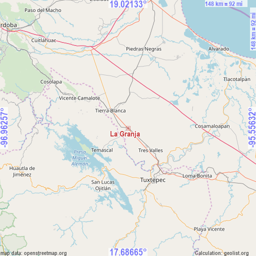
La Granja GPS coordinates[2]
18° 21' 19.008" North, 96° 15' 33.984" West
| Map corner | latitude | longitude |
|---|---|---|
| Upper-left | 19.02133°, | -96.96257° |
| Center: | 18.35528°, | -96.25944° |
| Lower-right: | 17.68665°, | -95.55632° |
| Map W x H: | 148.4×148.4 km | = 92.2×92.2mi |
| max Lat: | 32.7° ⇑74.3% North |
| La Granja: | 18.35528° |
| min Lat: | ⇓25.7% South 14.53588° |
| min Long | La Granja | max Long |
| -117.105° | -96.25944° | -86.73105° |
| W 81%⇐ | ⇒19% E |
Elevation
Elevation of La Granja is 48 m = 157 ft, and this is 1205.7 m = 3956 ft below average elevation for this country.
| Max E: |
3497 m = 11473 ft | 84.5% |
| Avg. | 1253.7 m = 4113 ft | |
| La Granja | 48 m = 157 ft | |
Min E: |
-1 m = -3 ft | 15.5% |
See also: Mexico elevation on elevation.city.
Geographical zone
La Granja is located in North Torrid zone (between Equator and Tropic of Cancer). Distance of this Northern Tropic circle is 565 km =351.1 mi to North.| Distance of | km | miles | from La Granja |
|---|---|---|---|
| North Pole | 7966.1 | 4949.9 | to North |
| Arctic Circle | 5360.3 | 3330.7 | to North |
| Tropic Cancer | 565 | 351.1 | to North |
| Equator | 2040.9 | 1268.2 | to South |


Nearby cities:
15 places around La Granja: (largest is in red/bold)
• Arroyo de Pita
11.6 km =7.2 mi,  291°
291°
• Corral de Piedra
13.2 km =8.2 mi,  201°
201°
• El Nuevo Manantial
10.5 km =6.5 mi,  160°
160°
• La Atalaya
6.9 km =4.3 mi,  316°
316°
• La Raya
12.6 km =7.8 mi,  295°
295°
• La Reforma
8.3 km =5.2 mi,  226°
226°
• La Reforma
9.9 km =6.2 mi, 232°
• Las Margaritas
11.5 km =7.1 mi,  193°
193°
• Las Yaguas
5 km =3.1 mi,  136°
136°
• Los Naranjos
9.9 km =6.2 mi,  90°
90°
• Nuevo Paso Nazareno (Chichicazapa)
11.3 km =7 mi, 234°
• Nuevo Pescadito de Málzaga (La Breña)
12.9 km =8 mi,  268°
268°
• Palma Sola
10.7 km =6.6 mi,  309°
309°
• Paso Rincón
10.4 km =6.5 mi, 198°
• Rancho Grande
9.5 km =5.9 mi, 269°
Sources, notices
• [Note1] Compared only with cities in Mexico existing in our database
• [Src1] Map data: © OpenStreetMap contributors (CC-BY-SA)
• [Src2] Other city data from geonames.org with taken over terms of usage.
• [Src3] Geographical zone / Annual Mean Temperature by Robert A. Rohde @ Wikipedia
