Paso Rincón geodata
Paso Rincón (Oaxaca) is a populated place; located in Mexico in America/Mexico_City (GMT-6) time zone. With population of 596 people, there are 14429 cities with bigger population in this country. Compared to other cities in Mexico, 75.4% of cities are located further ↑North; 80.9% of cities are located further ←West and 87% of cities have higher elevation than Paso Rincón. Note1


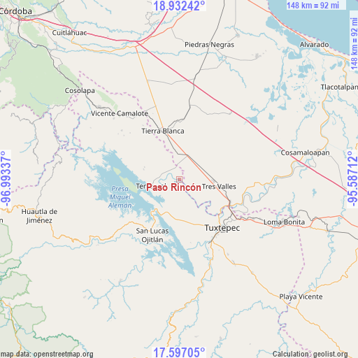
Paso Rincón GPS coordinates[2]
18° 15' 57.672" North, 96° 17' 24.864" West
| Map corner | latitude | longitude |
|---|---|---|
| Upper-left | 18.93242°, | -96.99337° |
| Center: | 18.26602°, | -96.29024° |
| Lower-right: | 17.59705°, | -95.58712° |
| Map W x H: | 148.5×148.5 km | = 92.3×92.3mi |
| max Lat: | 32.7° ⇑75.4% North |
| Paso Rincón: | 18.26602° |
| min Lat: | ⇓24.6% South 14.53588° |
| min Long | Paso Rincón | max Long |
| -117.105° | -96.29024° | -86.73105° |
| W 80.9%⇐ | ⇒19.1% E |
Elevation
Elevation of Paso Rincón is 34 m = 112 ft, and this is 1219.7 m = 4002 ft below average elevation for this country.
| Max E: |
3497 m = 11473 ft | 87% |
| Avg. | 1253.7 m = 4113 ft | |
| Paso Rincón | 34 m = 112 ft | |
Min E: |
-1 m = -3 ft | 13% |
See also: Mexico elevation on elevation.city.
Geographical zone
Paso Rincón is located in North Torrid zone (between Equator and Tropic of Cancer). Distance of this Northern Tropic circle is 574.9 km =357.2 mi to North.| Distance of | km | miles | from Paso Rincón |
|---|---|---|---|
| North Pole | 7976.1 | 4956.1 | to North |
| Arctic Circle | 5370.2 | 3336.9 | to North |
| Tropic Cancer | 574.9 | 357.2 | to North |
| Equator | 2031 | 1262 | to South |


Nearby cities:
15 places around Paso Rincón: (largest is in red/bold)
• Arroyo Chical (Nuevo Arroyo Chicali)
7.4 km =4.6 mi,  221°
221°
• Corral de Piedra
2.8 km =1.7 mi, 215°
• El Capulín (La Nueva Pochota)
4.2 km =2.6 mi,  162°
162°
• El Encajonado
10.6 km =6.6 mi,  254°
254°
• El Nuevo Manantial
6.8 km =4.2 mi,  89°
89°
• La Granja
10.4 km =6.5 mi,  18°
18°
• La Reforma
5 km =3.1 mi,  326°
326°
• La Reforma
6 km =3.7 mi,  309°
309°
• Las Margaritas
1.4 km =0.9 mi,  152°
152°
• Las Yaguas
9.1 km =5.7 mi,  46°
46°
• Nuevo Paso Nacional
11.5 km =7.1 mi,  257°
257°
• Nuevo Paso Nazareno (Chichicazapa)
6.9 km =4.3 mi,  299°
299°
• Nuevo Pescadito de Abajo
7.4 km =4.6 mi, 245°
• Nuevo Pescadito de Enmedio
9.3 km =5.8 mi,  273°
273°
• Rancho Grande
11.6 km =7.2 mi, 327°
Sources, notices
• [Note1] Compared only with cities in Mexico existing in our database
• [Src1] Map data: © OpenStreetMap contributors (CC-BY-SA)
• [Src2] Other city data from geonames.org with taken over terms of usage.
• [Src3] Geographical zone / Annual Mean Temperature by Robert A. Rohde @ Wikipedia
