Las Choapas geodata
Las Choapas (Veracruz) is a seat of a second-order administrative division; located in Mexico in America/Mexico_City (GMT-6) time zone. With population of 42,693 people, there are 250 cities with bigger population in this country. Compared to other cities in Mexico, 79.6% of cities are located further ↑North; 85.8% of cities are located further ←West and 90.8% of cities have higher elevation than Las Choapas. Note1


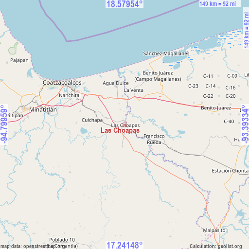
Las Choapas GPS coordinates[2]
17° 54' 42.372" North, 94° 5' 47.256" West
| Map corner | latitude | longitude |
|---|---|---|
| Upper-left | 18.57954°, | -94.79959° |
| Center: | 17.91177°, | -94.09646° |
| Lower-right: | 17.24148°, | -93.39334° |
| Map W x H: | 148.8×148.8 km | = 92.5×92.5mi |
| max Lat: | 32.7° ⇑79.6% North |
| Las Choapas: | 17.91177° |
| min Lat: | ⇓20.4% South 14.53588° |
| min Long | Las Choapas | max Long |
| -117.105° | -94.09646° | -86.73105° |
| W 85.8%⇐ | ⇒14.2% E |
Elevation
Elevation of Las Choapas is 22 m = 72 ft, and this is 1231.7 m = 4041 ft below average elevation for this country.
| Max E: |
3497 m = 11473 ft | 90.8% |
| Avg. | 1253.7 m = 4113 ft | |
| Las Choapas | 22 m = 72 ft | |
Min E: |
-1 m = -3 ft | 9.2% |
See also: Las Choapas elevation on elevation.city.
Geographical zone
Las Choapas is located in North Torrid zone (between Equator and Tropic of Cancer). Distance of this Northern Tropic circle is 614.3 km =381.7 mi to North.| Distance of | km | miles | from Las Choapas |
|---|---|---|---|
| North Pole | 8015.5 | 4980.6 | to North |
| Arctic Circle | 5409.6 | 3361.4 | to North |
| Tropic Cancer | 614.3 | 381.7 | to North |
| Equator | 1991.6 | 1237.5 | to South |


Nearby cities:
15 places around Las Choapas: (largest is in red/bold)
• Agua Dulce
25.8 km =16 mi,  348°
348°
• Blasillo 1ra. Sección (Nicolás Bravo)
26.4 km =16.4 mi,  45°
45°
• Blasillo 2da. Sección (Otates)
23.6 km =14.7 mi,  43°
43°
• Cuichapa
19.6 km =12.2 mi,  278°
278°
• El Encanto
9.5 km =5.9 mi,  344°
344°
• El Veinticinco
28.4 km =17.6 mi,  295°
295°
• Francisco Rueda
19.5 km =12.1 mi,  118°
118°
• La Concepción
27.5 km =17.1 mi,  256°
256°
• Los Manantiales
17.2 km =10.7 mi,  355°
355°
• Moloacán
27.8 km =17.3 mi,  287°
287°
• San José del Carmen
4.8 km =3 mi,  165°
165°
• Tlacuilolapan
19.1 km =11.9 mi, 292°
• Tres Bocas 1ra. Sección
23.6 km =14.7 mi,  84°
84°
• Villa la Venta
21.5 km =13.4 mi,  14°
14°
• Zanapa 1ra. Sección
27.1 km =16.8 mi, 79°
Sources, notices
• [Note1] Compared only with cities in Mexico existing in our database
• [Src1] Map data: © OpenStreetMap contributors (CC-BY-SA)
• [Src2] Other city data from geonames.org with taken over terms of usage.
• [Src3] Geographical zone / Annual Mean Temperature by Robert A. Rohde @ Wikipedia
