El Encanto geodata
El Encanto (Veracruz) is a populated place; located in Mexico in America/Mexico_City (GMT-6) time zone. With population of 754 people, there are 11619 cities with bigger population in this country. Compared to other cities in Mexico, 78.7% of cities are located further ↑North; 85.7% of cities are located further ←West and 89.7% of cities have higher elevation than El Encanto. Note1


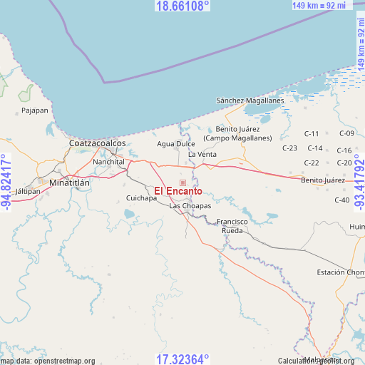
El Encanto GPS coordinates[2]
17° 59' 37.068" North, 94° 7' 15.744" West
| Map corner | latitude | longitude |
|---|---|---|
| Upper-left | 18.66108°, | -94.82417° |
| Center: | 17.99363°, | -94.12104° |
| Lower-right: | 17.32364°, | -93.41792° |
| Map W x H: | 148.7×148.7 km | = 92.4×92.4mi |
| max Lat: | 32.7° ⇑78.7% North |
| El Encanto: | 17.99363° |
| min Lat: | ⇓21.3% South 14.53588° |
| min Long | El Encanto | max Long |
| -117.105° | -94.12104° | -86.73105° |
| W 85.7%⇐ | ⇒14.3% E |
Elevation
Elevation of El Encanto is 25 m = 82 ft, and this is 1228.7 m = 4031 ft below average elevation for this country.
| Max E: |
3497 m = 11473 ft | 89.7% |
| Avg. | 1253.7 m = 4113 ft | |
| El Encanto | 25 m = 82 ft | |
Min E: |
-1 m = -3 ft | 10.3% |
See also: Mexico elevation on elevation.city.
Geographical zone
El Encanto is located in North Torrid zone (between Equator and Tropic of Cancer). Distance of this Northern Tropic circle is 605.2 km =376.1 mi to North.| Distance of | km | miles | from El Encanto |
|---|---|---|---|
| North Pole | 8006.4 | 4974.9 | to North |
| Arctic Circle | 5400.5 | 3355.7 | to North |
| Tropic Cancer | 605.2 | 376.1 | to North |
| Equator | 2000.7 | 1243.2 | to South |


Nearby cities:
15 places around El Encanto: (largest is in red/bold)
• Agua Dulce
16.4 km =10.2 mi,  351°
351°
• Blasillo 1ra. Sección (Nicolás Bravo)
23.4 km =14.5 mi,  66°
66°
• Blasillo 2da. Sección (Otates)
20.5 km =12.7 mi, 67°
• Cuauhtemoczin
23.4 km =14.5 mi,  358°
358°
• Cuichapa
17.9 km =11.1 mi,  250°
250°
• El Barí 1ra. Sección
24.6 km =15.3 mi,  9°
9°
• El Veinticinco
23.2 km =14.4 mi,  277°
277°
• Las Choapas
9.5 km =5.9 mi,  164°
164°
• Los Manantiales
8.2 km =5.1 mi, 8°
• Moloacán
23.9 km =14.9 mi,  267°
267°
• Nuevo Teapa
22.9 km =14.2 mi,  292°
292°
• San José del Carmen
14.3 km =8.9 mi, 164°
• Tlacuilolapan
15.1 km =9.4 mi,  263°
263°
• Tonalá
23.8 km =14.8 mi, 354°
• Villa la Venta
14.1 km =8.8 mi,  34°
34°
Sources, notices
• [Note1] Compared only with cities in Mexico existing in our database
• [Src1] Map data: © OpenStreetMap contributors (CC-BY-SA)
• [Src2] Other city data from geonames.org with taken over terms of usage.
• [Src3] Geographical zone / Annual Mean Temperature by Robert A. Rohde @ Wikipedia
