Cuichapa geodata
Cuichapa (Veracruz) is a populated place; located in Mexico in America/Mexico_City (GMT-6) time zone. With population of 7,697 people, there are 1210 cities with bigger population in this country. Compared to other cities in Mexico, 79.3% of cities are located further ↑North; 85.7% of cities are located further ←West and 87% of cities have higher elevation than Cuichapa. Note1


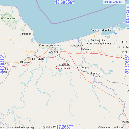
Cuichapa GPS coordinates[2]
17° 56' 20.004" North, 94° 16' 48" West
| Map corner | latitude | longitude |
|---|---|---|
| Upper-left | 18.60656°, | -94.98313° |
| Center: | 17.93889°, | -94.28° |
| Lower-right: | 17.2687°, | -93.57688° |
| Map W x H: | 148.8×148.8 km | = 92.5×92.5mi |
| max Lat: | 32.7° ⇑79.3% North |
| Cuichapa: | 17.93889° |
| min Lat: | ⇓20.7% South 14.53588° |
| min Long | Cuichapa | max Long |
| -117.105° | -94.28° | -86.73105° |
| W 85.7%⇐ | ⇒14.3% E |
Elevation
Elevation of Cuichapa is 34 m = 112 ft, and this is 1219.7 m = 4002 ft below average elevation for this country.
| Max E: |
3497 m = 11473 ft | 87% |
| Avg. | 1253.7 m = 4113 ft | |
| Cuichapa | 34 m = 112 ft | |
Min E: |
-1 m = -3 ft | 13% |
See also: Mexico elevation on elevation.city.
Geographical zone
Cuichapa is located in North Torrid zone (between Equator and Tropic of Cancer). Distance of this Northern Tropic circle is 611.3 km =379.8 mi to North.| Distance of | km | miles | from Cuichapa |
|---|---|---|---|
| North Pole | 8012.4 | 4978.7 | to North |
| Arctic Circle | 5406.6 | 3359.5 | to North |
| Tropic Cancer | 611.3 | 379.8 | to North |
| Equator | 1994.6 | 1239.4 | to South |


Nearby cities:
15 places around Cuichapa: (largest is in red/bold)
• El Chapo
14.1 km =8.8 mi,  327°
327°
• El Encanto
17.9 km =11.1 mi,  70°
70°
• El Veinticinco
11.1 km =6.9 mi, 326°
• Ixhuatlán del Sureste
14.7 km =9.1 mi,  308°
308°
• La Candelaria [Unidad Habitacional]
17.2 km =10.7 mi, 312°
• La Concepción
11.8 km =7.3 mi,  218°
218°
• Las Choapas
19.6 km =12.2 mi,  98°
98°
• Las Águilas
15.9 km =9.9 mi, 312°
• Los Manantiales
22.9 km =14.2 mi,  51°
51°
• Moloacán
8.8 km =5.5 mi, 306°
• Mundo Nuevo
20.3 km =12.6 mi,  324°
324°
• Nanchital de Lázaro Cárdenas del Río
20 km =12.4 mi, 317°
• Nuevo Teapa
15.5 km =9.6 mi,  343°
343°
• San José del Carmen
22.1 km =13.7 mi,  110°
110°
• Tlacuilolapan
4.7 km =2.9 mi,  22°
22°
Sources, notices
• [Note1] Compared only with cities in Mexico existing in our database
• [Src1] Map data: © OpenStreetMap contributors (CC-BY-SA)
• [Src2] Other city data from geonames.org with taken over terms of usage.
• [Src3] Geographical zone / Annual Mean Temperature by Robert A. Rohde @ Wikipedia
