Los Manantiales geodata
Los Manantiales (Veracruz) is a populated place; located in Mexico in America/Mexico_City (GMT-6) time zone. With population of 651 people, there are 13306 cities with bigger population in this country. Compared to other cities in Mexico, 77.9% of cities are located further ↑North; 85.8% of cities are located further ←West and 94.6% of cities have higher elevation than Los Manantiales. Note1


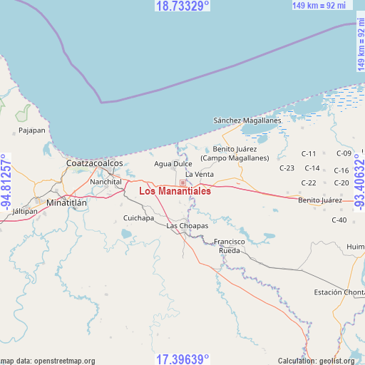
Los Manantiales GPS coordinates[2]
18° 3' 57.996" North, 94° 6' 33.984" West
| Map corner | latitude | longitude |
|---|---|---|
| Upper-left | 18.73329°, | -94.81257° |
| Center: | 18.06611°, | -94.10944° |
| Lower-right: | 17.39639°, | -93.40632° |
| Map W x H: | 148.6×148.7 km | = 92.3×92.4mi |
| max Lat: | 32.7° ⇑77.9% North |
| Los Manantiales: | 18.06611° |
| min Lat: | ⇓22.1% South 14.53588° |
| min Long | Los Manantiales | max Long |
| -117.105° | -94.10944° | -86.73105° |
| W 85.8%⇐ | ⇒14.2% E |
Elevation
Elevation of Los Manantiales is 14 m = 46 ft, and this is 1239.7 m = 4067 ft below average elevation for this country.
| Max E: |
3497 m = 11473 ft | 94.6% |
| Avg. | 1253.7 m = 4113 ft | |
| Los Manantiales | 14 m = 46 ft | |
Min E: |
-1 m = -3 ft | 5.4% |
See also: Mexico elevation on elevation.city.
Geographical zone
Los Manantiales is located in North Torrid zone (between Equator and Tropic of Cancer). Distance of this Northern Tropic circle is 597.2 km =371.1 mi to North.| Distance of | km | miles | from Los Manantiales |
|---|---|---|---|
| North Pole | 7998.3 | 4969.9 | to North |
| Arctic Circle | 5392.4 | 3350.7 | to North |
| Tropic Cancer | 597.2 | 371.1 | to North |
| Equator | 2008.8 | 1248.2 | to South |


Nearby cities:
15 places around Los Manantiales: (largest is in red/bold)
• Agua Dulce
9 km =5.6 mi,  334°
334°
• Blasillo 1ra. Sección (Nicolás Bravo)
20.2 km =12.6 mi,  86°
86°
• Blasillo 2da. Sección (Otates)
17.7 km =11 mi, 90°
• Cuauhtemoczin
15.4 km =9.6 mi,  353°
353°
• Cuichapa
22.9 km =14.2 mi,  231°
231°
• El Barí 1ra. Sección
16.4 km =10.2 mi,  10°
10°
• El Encanto
8.2 km =5.1 mi,  188°
188°
• El Yucateco
19 km =11.8 mi,  30°
30°
• Guillermo Prieto
20.6 km =12.8 mi,  300°
300°
• Las Choapas
17.2 km =10.7 mi,  175°
175°
• Nuevo Teapa
22.4 km =13.9 mi,  271°
271°
• San José del Carmen
22 km =13.7 mi,  173°
173°
• Tlacuilolapan
19 km =11.8 mi,  238°
238°
• Tonalá
16 km =9.9 mi, 347°
• Villa la Venta
7.6 km =4.7 mi,  61°
61°
Sources, notices
• [Note1] Compared only with cities in Mexico existing in our database
• [Src1] Map data: © OpenStreetMap contributors (CC-BY-SA)
• [Src2] Other city data from geonames.org with taken over terms of usage.
• [Src3] Geographical zone / Annual Mean Temperature by Robert A. Rohde @ Wikipedia
