Larráinzar geodata
Larráinzar (Chiapas) is a seat of a second-order administrative division; located in Mexico in America/Mexico_City (GMT-6) time zone. With population of 2,364 people, there are 3734 cities with bigger population in this country. Compared to other cities in Mexico, 90.6% of cities are located further ↑North; 90.4% of cities are located further ←West and 74.3% of cities have lower elevation than Larráinzar. Note1


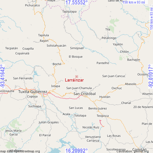
Larráinzar GPS coordinates[2]
16° 53' 2.112" North, 92° 42' 47.844" West
| Map corner | latitude | longitude |
|---|---|---|
| Upper-left | 17.55552°, | -93.41642° |
| Center: | 16.88392°, | -92.71329° |
| Lower-right: | 16.20992°, | -92.01017° |
| Map W x H: | 149.6×149.6 km | = 93×93mi |
| max Lat: | 32.7° ⇑90.6% North |
| Larráinzar: | 16.88392° |
| min Lat: | ⇓9.4% South 14.53588° |
| min Long | Larráinzar | max Long |
| -117.105° | -92.71329° | -86.73105° |
| W 90.4%⇐ | ⇒9.6% E |
Elevation
Elevation of Larráinzar is 2018 m = 6621 ft, and this is 764.3 m = 2508 ft above average elevation for this country.
| Max E: |
3497 m = 11473 ft | 25.7% |
| Larráinzar | 2018 m 6621 ft | |
| Avg. | 1253.7 m = 4113 ft | |
Min E: |
-1 m = -3 ft | 74.3% |
See also: Mexico elevation on elevation.city.
Geographical zone
Larráinzar is located in North Torrid zone (between Equator and Tropic of Cancer). Distance of this Northern Tropic circle is 728.6 km =452.7 mi to North.| Distance of | km | miles | from Larráinzar |
|---|---|---|---|
| North Pole | 8129.7 | 5051.6 | to North |
| Arctic Circle | 5523.9 | 3432.4 | to North |
| Tropic Cancer | 728.6 | 452.7 | to North |
| Equator | 1877.3 | 1166.5 | to South |


Nearby cities:
15 places around Larráinzar: (largest is in red/bold)
• Aldama
4.5 km =2.8 mi,  35°
35°
• Bayalemo Dos
7.9 km =4.9 mi,  314°
314°
• Belisario Domínguez
5.7 km =3.5 mi,  81°
81°
• Caridad San Antonio
7.3 km =4.5 mi,  52°
52°
• Cruz Quemada
6.9 km =4.3 mi,  162°
162°
• Epalchén
2 km =1.2 mi,  65°
65°
• Icalumtic
6.2 km =3.9 mi,  110°
110°
• Jolnachoj
7.6 km =4.7 mi,  297°
297°
• Jomalho
5 km =3.1 mi,  184°
184°
• Macvilhó
3.6 km =2.2 mi,  145°
145°
• Majomut
6.9 km =4.3 mi,  123°
123°
• Muctahuitz
4.9 km =3 mi,  249°
249°
• Pilalchén
5.7 km =3.5 mi, 148°
• Santiago el Pinar
6.3 km =3.9 mi,  358°
358°
• Tentic
4 km =2.5 mi, 124°
Sources, notices
• [Note1] Compared only with cities in Mexico existing in our database
• [Src1] Map data: © OpenStreetMap contributors (CC-BY-SA)
• [Src2] Other city data from geonames.org with taken over terms of usage.
• [Src3] Geographical zone / Annual Mean Temperature by Robert A. Rohde @ Wikipedia
