Macvilhó geodata
Macvilhó (Chiapas) is a populated place; located in Mexico in America/Mexico_City (GMT-6) time zone. With population of 1,142 people, there are 7607 cities with bigger population in this country. Compared to other cities in Mexico, 90.9% of cities are located further ↑North; 90.5% of cities are located further ←West and 80.6% of cities have lower elevation than Macvilhó. Note1


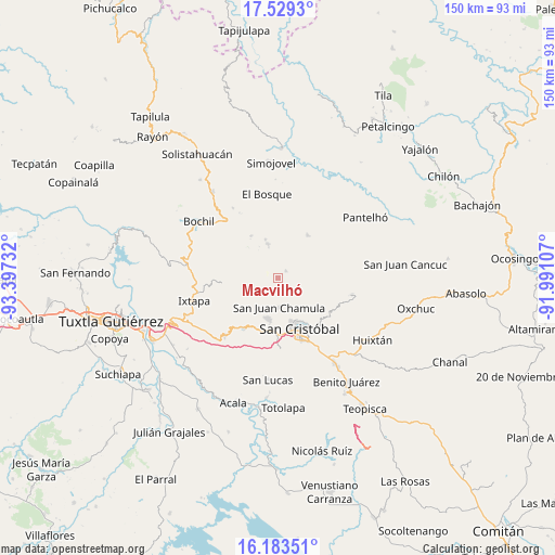
Macvilhó GPS coordinates[2]
16° 51' 27.36" North, 92° 41' 39.084" West
| Map corner | latitude | longitude |
|---|---|---|
| Upper-left | 17.5293°, | -93.39732° |
| Center: | 16.8576°, | -92.69419° |
| Lower-right: | 16.18351°, | -91.99107° |
| Map W x H: | 149.6×149.6 km | = 93×93mi |
| max Lat: | 32.7° ⇑90.9% North |
| Macvilhó: | 16.8576° |
| min Lat: | ⇓9.1% South 14.53588° |
| min Long | Macvilhó | max Long |
| -117.105° | -92.69419° | -86.73105° |
| W 90.5%⇐ | ⇒9.5% E |
Elevation
Elevation of Macvilhó is 2156 m = 7073 ft, and this is 902.3 m = 2960 ft above average elevation for this country.
| Max E: |
3497 m = 11473 ft | 19.4% |
| Macvilhó | 2156 m 7073 ft | |
| Avg. | 1253.7 m = 4113 ft | |
Min E: |
-1 m = -3 ft | 80.6% |
See also: Mexico elevation on elevation.city.
Geographical zone
Macvilhó is located in North Torrid zone (between Equator and Tropic of Cancer). Distance of this Northern Tropic circle is 731.5 km =454.5 mi to North.| Distance of | km | miles | from Macvilhó |
|---|---|---|---|
| North Pole | 8132.7 | 5053.4 | to North |
| Arctic Circle | 5526.8 | 3434.2 | to North |
| Tropic Cancer | 731.5 | 454.5 | to North |
| Equator | 1874.4 | 1164.7 | to South |


Nearby cities:
15 places around Macvilhó: (largest is in red/bold)
• Belisario Domínguez
5.2 km =3.2 mi,  43°
43°
• Chicviltenal
4.8 km =3 mi,  138°
138°
• Cruz Quemada
3.7 km =2.3 mi,  180°
180°
• Epalchén
3.8 km =2.4 mi,  356°
356°
• Icalumtic
3.9 km =2.4 mi,  79°
79°
• Jomalho
3.2 km =2 mi,  230°
230°
• Larráinzar
3.6 km =2.2 mi,  325°
325°
• Majomut
3.8 km =2.4 mi,  104°
104°
• Nichén
6.3 km =3.9 mi,  170°
170°
• Pilalchén
2.1 km =1.3 mi,  152°
152°
• Seteltón
6 km =3.7 mi,  214°
214°
• Shucutón
5.6 km =3.5 mi,  122°
122°
• Tentic
1.4 km =0.9 mi,  63°
63°
• Tzajalchén
5.6 km =3.5 mi,  113°
113°
• Tzajaltetic
5 km =3.1 mi,  187°
187°
Sources, notices
• [Note1] Compared only with cities in Mexico existing in our database
• [Src1] Map data: © OpenStreetMap contributors (CC-BY-SA)
• [Src2] Other city data from geonames.org with taken over terms of usage.
• [Src3] Geographical zone / Annual Mean Temperature by Robert A. Rohde @ Wikipedia
