Icalumtic geodata
Icalumtic (Chiapas) is a populated place; located in Mexico in America/Mexico_City (GMT-6) time zone. With population of 614 people, there are 14035 cities with bigger population in this country. Compared to other cities in Mexico, 90.9% of cities are located further ↑North; 90.8% of cities are located further ←West and 72.9% of cities have lower elevation than Icalumtic. Note1


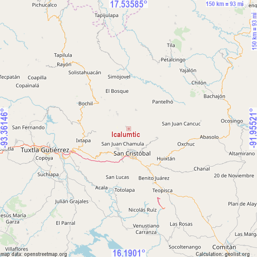
Icalumtic GPS coordinates[2]
16° 51' 51.012" North, 92° 39' 29.988" West
| Map corner | latitude | longitude |
|---|---|---|
| Upper-left | 17.53585°, | -93.36146° |
| Center: | 16.86417°, | -92.65833° |
| Lower-right: | 16.1901°, | -91.95521° |
| Map W x H: | 149.6×149.6 km | = 93×93mi |
| max Lat: | 32.7° ⇑90.9% North |
| Icalumtic: | 16.86417° |
| min Lat: | ⇓9.1% South 14.53588° |
| min Long | Icalumtic | max Long |
| -117.105° | -92.65833° | -86.73105° |
| W 90.8%⇐ | ⇒9.2% E |
Elevation
Elevation of Icalumtic is 1988 m = 6522 ft, and this is 734.3 m = 2409 ft above average elevation for this country.
| Max E: |
3497 m = 11473 ft | 27.1% |
| Icalumtic | 1988 m 6522 ft | |
| Avg. | 1253.7 m = 4113 ft | |
Min E: |
-1 m = -3 ft | 72.9% |
See also: Mexico elevation on elevation.city.
Geographical zone
Icalumtic is located in North Torrid zone (between Equator and Tropic of Cancer). Distance of this Northern Tropic circle is 730.8 km =454.1 mi to North.| Distance of | km | miles | from Icalumtic |
|---|---|---|---|
| North Pole | 8131.9 | 5052.9 | to North |
| Arctic Circle | 5526.1 | 3433.8 | to North |
| Tropic Cancer | 730.8 | 454.1 | to North |
| Equator | 1875.1 | 1165.1 | to South |


Nearby cities:
15 places around Icalumtic: (largest is in red/bold)
• Bashequen
5.6 km =3.5 mi,  66°
66°
• Belisario Domínguez
3.1 km =1.9 mi,  355°
355°
• Chenalhó
4.7 km =2.9 mi,  45°
45°
• Chicviltenal
4.4 km =2.7 mi,  188°
188°
• Chiotic
4 km =2.5 mi,  117°
117°
• Epalchén
5.1 km =3.2 mi,  306°
306°
• Macvilhó
3.9 km =2.4 mi,  259°
259°
• Majomut
1.7 km =1.1 mi,  184°
184°
• Mitontic
3.2 km =2 mi,  85°
85°
• Pilalchén
3.9 km =2.4 mi,  227°
227°
• Shucutón
3.9 km =2.4 mi,  166°
166°
• Tentic
2.5 km =1.6 mi,  267°
267°
• Tzajalchén
3.3 km =2.1 mi,  156°
156°
• Yitic
3.5 km =2.2 mi,  102°
102°
• Yutniotic
4.8 km =3 mi, 164°
Sources, notices
• [Note1] Compared only with cities in Mexico existing in our database
• [Src1] Map data: © OpenStreetMap contributors (CC-BY-SA)
• [Src2] Other city data from geonames.org with taken over terms of usage.
• [Src3] Geographical zone / Annual Mean Temperature by Robert A. Rohde @ Wikipedia
